
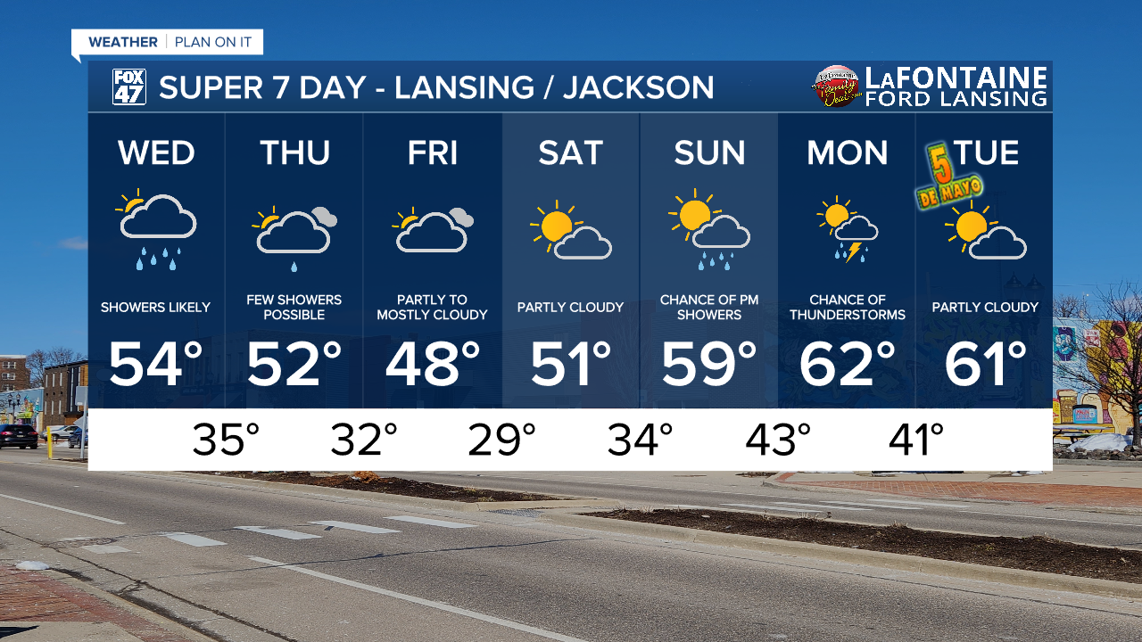
LANSING, Mich. — Scattered showers advance through our neighborhoods this morning affiliated with a surface low. However, we remain dry at the surface with dew points only in the 30's. These dry conditions are making it hard for any of this rain to reach the surface this morning. Pack the umbrella still as we will be tracking showers throughout the day today and into the evening hours.
Daytime highs warm into the mid 50's today as we continue the cooling trend due to an advancing upper level low ushering in well below average temperatures for this time of year. Expect cloudy skies and light rain showers throughout the day today.

WATCH THE FULL FORECAST BELOW
As a shortwave advances through our region today, showers will remain light during the daylight hours with some measurable rainfall possible into the early evening hours beginning after 2 PM today and lasting into the evening and possibly overnight hours. We still are not expecting any large rainfall accumulations from this round of showers today and paired with renewed rainfall tomorrow, we are only expecting up to possibly half an inch of rain.

With these showers continuing into the overnight hours, cloud cover will continue to act as a blanket to keep surface temperatures warm. We should still cool into the mid 30's tonight, but with this cloud cover and continued present winds, frost potential could be hindered. We will continue to watch, however, for any changes.

The main concern for chilly temperatures arrives Thursday night into Friday morning where, regardless of cloud cover and winds, air temperatures look to drop right around freezing. This could damage early season plants and crops. This problem will persist Friday night into Saturday morning with air temperatures dropping below freezing. Make sure to bring in any plants or cover them up during the overnight hours through Sunday morning as lows will warm back into the mid 30's with frost development still possible.
Feels like temperatures Thursday morning will hover around freezing for much of our neighborhoods with even cooler wind chills into Friday morning below freezing. Make sure to unpack that heavier jacket.

We hang on to cloudy skies Friday with some better chances for sunshine on Saturday as temperatures begin to warm. We will be back in the 60's for daytime highs early next week with returning chances for showers and thunderstorms Sunday and Monday.
Have a great weather picture or video to share? Send it our way and we may feature it on-air or online!

