
LANSING, Mich. — Strong winds and showers brought damage to multiple neighborhoods Monday afternoon and evening. There have been several reports of downed trees and power lines with a few damage reports to roofing and vehicles.
We are still observing power outages across our neighborhoods this morning as well following these damaging winds.
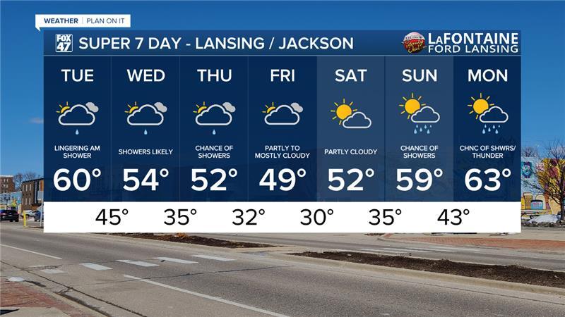
The good news is that this morning, the cold front will be advancing through our neighborhoods and we will begin to see calm conditions into the afternoon hours today as temperatures cool into the mid to upper 50's this afternoon. This is now below average for this time of year. Cloud cover will hang around for the majority of the day. Clearing is expected to take place late this afternoon allowing for some sunshine before we close the day.

WATCH THE FULL FORECAST BELOW
Winds on the back end of the cold front will remain strong through the morning hours with gusts up to 35 mph still possible. Once we reach the afternoon, a weakening trend will occur leading to calm wind speeds this evening and into the overnight hours.

Showers return to our neighborhoods past midnight with no major impacts as we will continue to see light showers continue during the daytime hours Wednesday and Thursday with ample cloud cover. Both Wednesday and Thursday showers are only looking to produce up to .3" of rainfall across our neighborhoods. Showers should remain scattered during the midweek period.

Temperatures will remain in the 50's and even possibly drop into the upper 40's on Friday. We are mainly watching our overnight lows as they fall into the 30's beginning Wednesday night. With seasonal plants beginning to bloom, we could see some impacts arise due to frost and a possible freeze. Lows will drop into the mid 30's Wednesday night into Thursday morning with feels like temperatures due to present winds dropping into the upper 20's. Make sure to have a heavier coat available as we won't see warmer temperatures until next week.

When forecasting potential frost, we are looking for overnight clear skies and weak winds with forecast temperatures in the mid to upper 30's. Wednesday night does have some potential clearing, however, present winds could hinder any frost development. Our main concern arises overnight Friday into Saturday where lows track below freezing. This freeze could impacts crops and plants. Make sure, if you planted early, to cover up plants or bring them inside until overnight lows warm again which won't occur until next week.
As temps begin to warm again, we will be watching for returning showers beginning Sunday and into Monday.
Have a great weather picture or video to share? Send it our way and we may feature it on-air or online!

