
LANSING, Mich. — The early morning hours Friday saw roadways dry up due to strong winds following rainfall from Thursday evening. The slow moving cold front allowed for freezing on roadways to diminish. However, we could still run into some isolated slick spots as well as lake effect snow dropping visibility. Leave some extra time when heading out on the roads today.
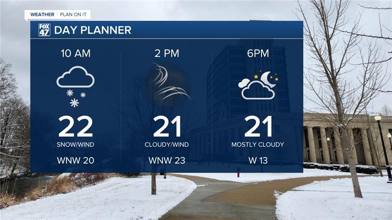
We will see lake effect snow showers through lunchtime today with mostly cloudy skies for the rest of the afternoon hours. Temperatures will hover in the lower 20's for the rest of the day today which is a major shift from what we've been seeing in our neighborhoods over the past couple of days.
WATCH THE FULL FORECAST BELOW
The National Weather Service has issued a Wind Advisory across most of our neighborhoods excluding Hillsdale County. This advisory is currently in effect and lasts through 7 PM Friday evening.

Peak wind gusts could reach 45 mph across all of our neighborhoods including Hillsdale which could allow for limited visibility during the AM drive as well as possible power outages. This peak in winds is looking to occur during the lunch hour today and gradually weakening as we progress through the afternoon hours.

This weekend brings a roller coaster temperatures trend as a ridge pattern builds into the region this evening. Winds will shift out of the south allowing high temps to warm back into the upper 30's for Saturday.
However, an incoming cold front will renew chances for both rain and snow Saturday afternoon with light accumulations up to an inch possible. We are watching for the 4 PM to 6 PM period Saturday for potential rain and snow across our northern neighborhoods.

Once this precipitation departs Saturday, temperatures will fall again with highs back in the 20's on Sunday and feels like temperatures potentially dropping below zero degrees Sunday morning.

We will start a new week with a warming trend and more snow and rain possible with light precip accumulations late Monday into Tuesday morning. We will stay dry on Christmas Eve Wednesday as high temps warm into the lower 40's. We could potentially see high temperatures reach the upper 40's and possibly 50 for Christmas with chances for rain showers. However, we could still see some changes to our holiday forecast and will be watching carefully.

Want more FOX 47 News? Here's how you download our Roku app
You can also see the latest news from across our mid-Michigan neighborhoods by liking us on Facebook or following us on X.
