
LANSING, Mich. — A Dense Fog Advisory remains in effect for Hillsdale County Thursday morning through 10 AM. We could see dense fog limit visibility less than a quarter of a mile. Make sure to stay weather aware when heading out on the roads this morning as returning moisture will create limited visibility across all of our neighborhoods.
Temperatures remain mild during the morning hours, but high temperatures in the afternoon only warm to the mid 40's. This is cooler than what we observed Wednesday across our neighborhoods. Another round of showers is expected late in the morning hours with no major impacts expected.

WATCH THE FULL FORECAST BELOW
The next round of rainfall is expected from 11 AM to 4 PM Thursday. Rain will enter from the south starting in Hillsdale County and make its way norther becoming widespread for Hillsdale and Jackson counties and more scattered for Eaton, Ingham, and Clinton counties. Our most southern neighborhoods could tap into some limited instability and produce a rumble of thunder, however, no severe impacts are expected today across any of our neighborhoods.

We will dry up for the rest of the evening and overnight period as Friday brings chances for storms which could produce some severe impacts. The Storm Prediction Center continues the marginal risk for isolated severe storms Friday evening across all of our neighborhoods. Major impacts we will be watching out for is hail and wind gusts exceeding 40 mph.

A warm front will advance through our neighborhoods Friday evening with showers and thunderstorms developing out ahead and along the frontal passage. A line of showers and storms is looking to develop from 5 PM to 9 PM across our neighborhoods with thunderstorms possibly producing isolated severe impacts such as hail and wind gusts in excess of 40 mph. Precipitation rates will also be elevated, however, no flooding concerns are expected.

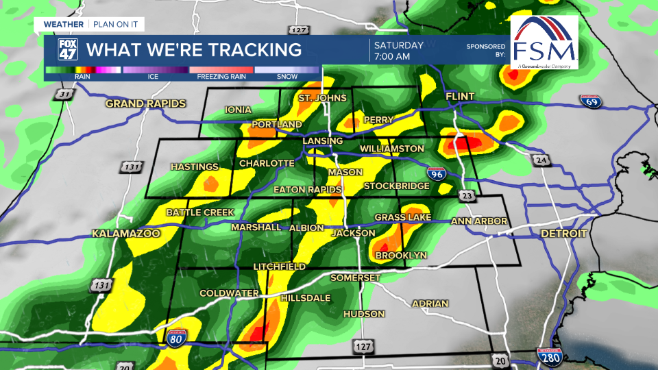
Following this round of evening storms, instability will hang around awaiting the incoming cold frontal passage which is looking to advance through Saturday. During the first half of the day, we could see another line of showers and thunderstorms develop from 5 AM to 9 AM. This round could still see some changes given the timing of the cold front as we lose out on instability heading into the overnight and early morning hours. If we see these showers come in any later, we could still see some hail and strong winds across our neighborhoods.
We will dry up Saturday afternoon as temperatures take a cool down back into the upper 50's Sunday where we also lose an hour of sleep and turn our clocks ahead an hour due to Daylight Saving Time beginning. We will quickly warm back into the mid to upper 60's Monday with mostly sunny skies and a run for 70 degrees possible. We are tracking the chances for more thunderstorms Tuesday and Wednesday with continued warm temperatures.

Want more FOX 47 News? Here's how you download our Roku app
You can also see the latest news from across our mid-Michigan neighborhoods by liking us on Facebook or following us on X.
