
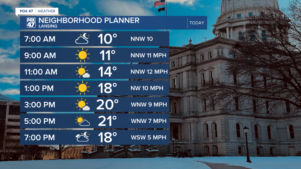
LANSING, Mich. — Snowfall brought a lot of problems to the state of Michigan Wednesday in terms of travel. As you wake up on Thursday with temperatures in the lower teens, slick spots on untreated roadways are expected. Treated roadways could also still see slick spots as salt becomes less effective once temperatures drop below 20 degrees. Still leave some extra time when heading out the door today and getting behind the wheel.
The good news for Thursday is a ridging pattern enters the state which will clear our cloud cover this morning and allow for sunshine into the afternoon hours. However, with winds still out of the north, high temperatures will only reach the lower 20's.
WATCH THE FULL FORECAST BELOW
Overnight tonight, clouds will increase across our neighborhood as our next clipper system approaches and advances through our neighborhoods slowly as we progress through the weekend. Snow is expected to arrive at around 5 AM Friday morning with more uniform snow showers expected from 6 AM to Noon. This could bring some impacts to the morning commute Friday with strong winds and limited visibility.
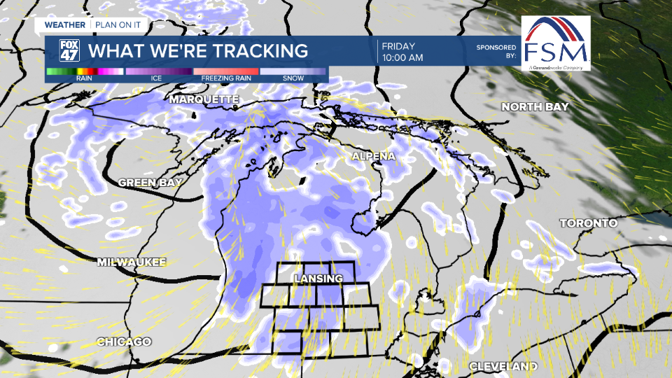
Snow totals as this clipper continues on through Saturday and exiting by Sunday morning shows a general 1-3" of snow across our neighborhoods. 2-3" is favored for our more northerly neighborhoods, while southern neighborhoods could see more along the lines of 1-2". Snow showers remain scattered Friday afternoon through Sunday morning. Some tweaks could still exist in this forecast as we approach the overnight hours. Make sure to keep an eye on the forecast.

Temperatures Friday warm to freezing which is right around where we should be for this time of year. However, Friday also commences a gradual cool down in temperatures. By Sunday, we will see highs in the lower 20's and starting a new week with lows in the single digits. Monday brings returning chances of snow showers with highs in the mid teens as we continue to cool into Tuesday. Wednesday is when we can finally expect a warm up in our neighborhoods with highs back into the lower 20's with renewed chances for snowfall.

Want more FOX 47 News? Here's how you download our Roku app
You can also see the latest news from across our mid-Michigan neighborhoods by liking us on Facebook or following us on X.
