
NOON UPDATE
The High Wind Warning across our neighborhoods has been canceled this afternoon with a Wind Advisory being issued in place as winds begin to gradually weaken into the Monday afternoon hours. We can expect gusts to possibly reach 50 mph with blowing snow still allowing for slick roadways throughout the rest of the day. Additional powers outages are still possible.
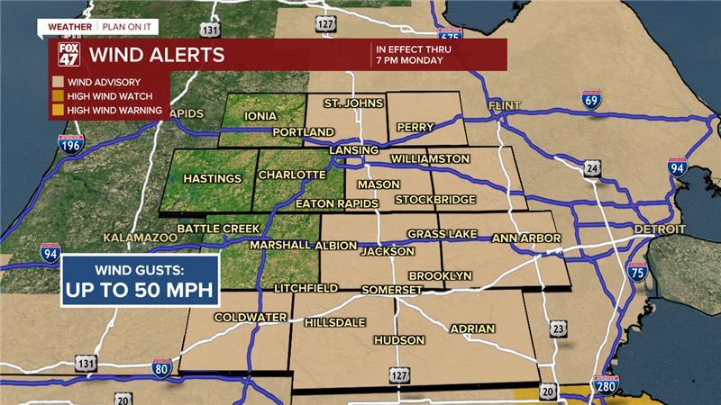
We saw wind gusts up to 54 mph in Jackson at 12:05 AM and 49 mph in Lansing at 5:16 AM. Power outages across our neighborhoods have already been improving since the early morning hours.
Snow will continue in Hillsdale County with light accumulations as our northern neighborhoods should start to see snow taper heading into these early afternoon hours. Still keep it slow on the roads and leave extra time to get to your destination.
ORIGINAL POST
Following a mild end to the weekend with some neighborhoods able to reach the lower 60's, colder air returns to our neighborhoods to start the day Monday.
As a low pressure system advances through the region, we are observing strong winds along a strong pressure gradient Monday. A High Wind Warning is currently in effect for Clinton, Ingham, and Jackson counties with a Wind Advisory in effect for Hillsdale County. We could see gusts during the first half of the day reach 55 mph with a 60 mph gust not out of the question in the state today.
Winds this strong could blow over power lines as well as create power outages. We have already seen over 1,400 customers without power as of 6 AM Monday morning across our neighborhoods.

WATCH THE FULL FORECAST BELOW
To the west, cold air is allowing for lake effect snow to setup in our western neighborhoods making its way into Eaton County. A Winter Weather Advisory is currently in effect through 7 PM Monday evening for accumulations possibly reaching 3" in Eaton County.

With falling temperatures today below freezing, a concern lies for wet, untreated roadways to possibly freeze over paired with snowfall could create slick roadways throughout the day today and into tomorrow morning. Stay weather aware when heading out the door.

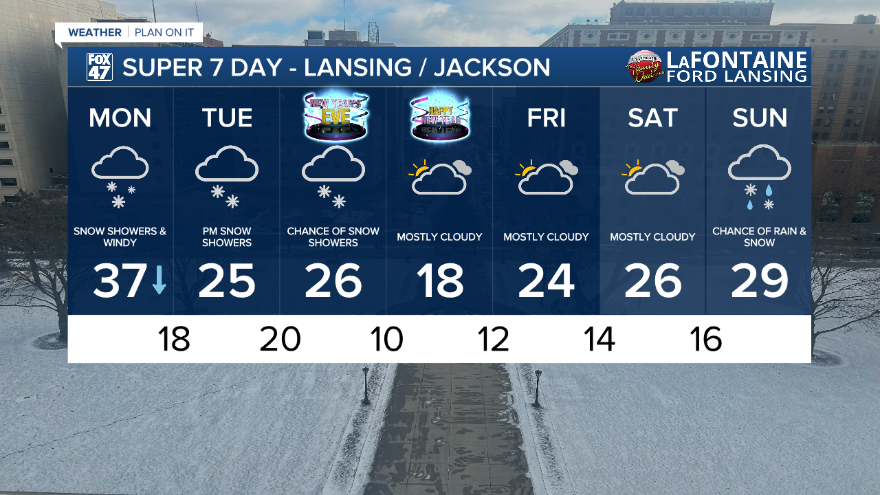
Throughout the afternoon hours, winds will gradually weaken with conditions still breezy ranging from 30-35 mph. Snow is also looking to come to an end following the early afternoon hours. However, slick spots on untreated roadways could remain.
Make sure to take it slow during all the AM hours Monday as we will see much of our snowfall during this period. We could see 2-3" across all of our neighborhoods by the time we close the day.

We will have renewed rounds of snow beginning Tuesday PM and into the first half of the day Wednesday with lighter accumulations than what we are expecting today. We could see 1 to 2 inches of snowfall during this second rounds. We will dry up heading into the new year.
Want more FOX 47 News? Here's how you download our Roku app
You can also see the latest news from across our mid-Michigan neighborhoods by liking us on Facebook or following us on X.
