
LANSING, Mich. — We are already waking up to snowfall across our neighborhoods as some light snow moved through our neighborhoods bringing a dusting to some neighborhoods. Roads for the morning commute shouldn't be impacted too badly, but stay weather aware as we track more snowfall throughout the day.
High temperatures reach the lower 30's today which is right around where we should be. However, this daytime high will occur later this evening as this afternoon temps will continue warming into the upper 20's.
WATCH THE FULL FORECAST BELOW
Our next round of snow arrives during the lunchtime hours today from 11 AM to 4 PM as the clipper system arrives affiliated with a weakening occluded front. Snow showers could bring limited visibility and slick spots as we could see up to 2 inches of our accumulations from this round of snow alone.

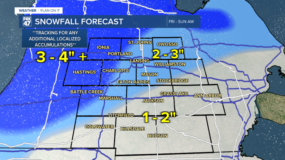
Scattered snow continues across our neighborhoods Friday evening and throughout the day Saturday into Sunday morning as we hang onto the influence of this slow moving clipper system. Snow totals today through Sunday morning show a general 1-3" of snowfall across our neighborhoods. However, we will need to watch for localized areas possibly seeing an additional inch in areas of heavier snowfall rates.
Winds pick back up today with gusts in the early afternoon hours possibly reaching 40 mph. This will allow for potential blowing snow on roadways as it starts to accumulate. These strong winds will continue into the day Saturday with max wind gusts weakening to the 30-35mph range.

Today will be the warmest day of our 7-Day forecast as we gradually cool throughout the day Saturday with highs in the lower 20's as we wrap up the influence of this slow moving clipper Sunday. We start the week with more snow potential as high temperatures only reach the mid to lower teens and overnight lows in the single digits nearing zero. We will need to watch for cold impacts when heading into the new week.

Want more FOX 47 News? Here's how you download our Roku app
You can also see the latest news from across our mid-Michigan neighborhoods by liking us on Facebook or following us on X.
