
10 AM UPDATE
A Winter Weather Advisory has been issued across all of our neighborhoods through 7 PM this evening. After snowfall of around an inch fell this morning, additional light snow and freezing drizzle will fall across our neighborhoods renewing the risks for slippery road conditions that could linger into the evening commute.

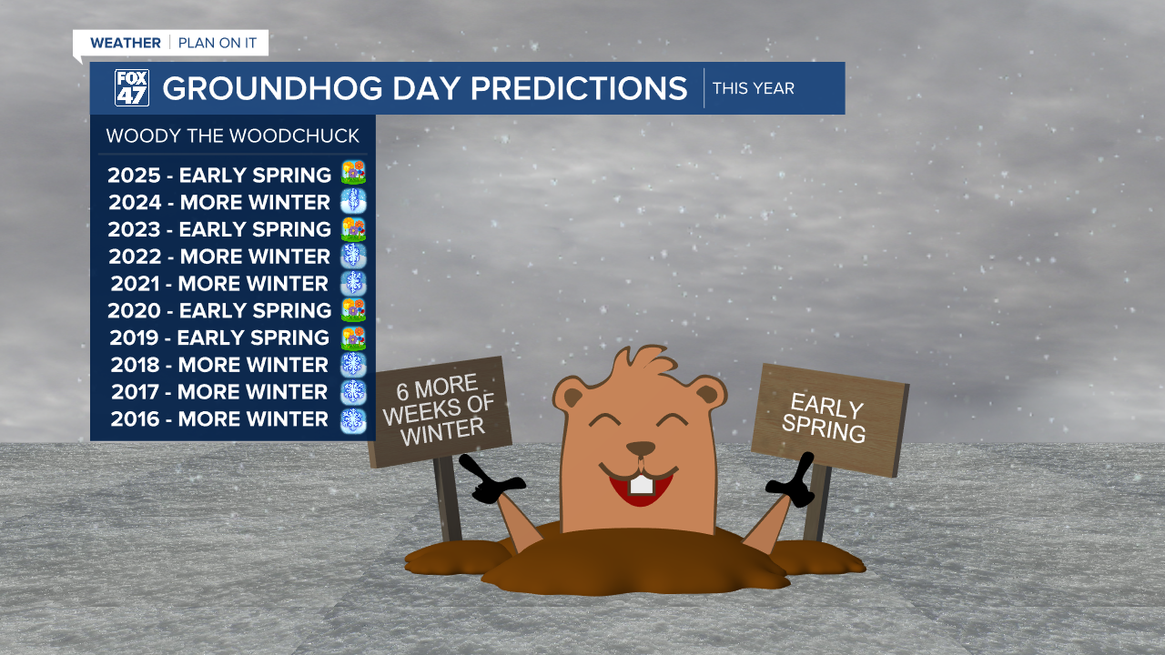
This winter weather fits perfectly with Woody the Woodchuck and Punxsutawney Phil's predictions of 6 more weeks of winter from this morning.
ORIGINAL POST
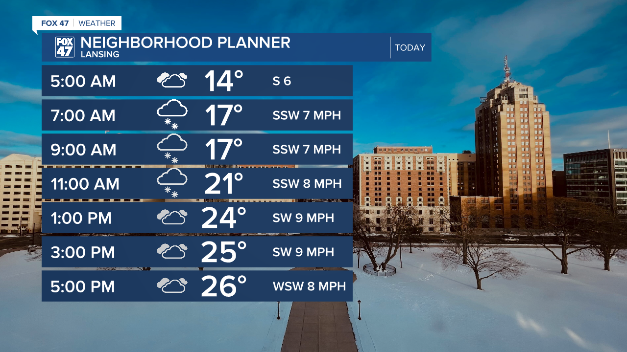
Sunday brought lots of sunshine to our neighborhoods with temperatures gradually warming. We will continue to feel this warm up today as high temperatures reach the mid 20's. This is still a bit below average for this time of year. However, these temps are a big improvement compared to what we observed last week.
Winds out of the south aid in this warm up today with gusts up to 25 mph during the early afternoon hours. We are also tracking snowfall during the AM hours with light accumulations expected.
WATCH THE FULL FORECAST BELOW
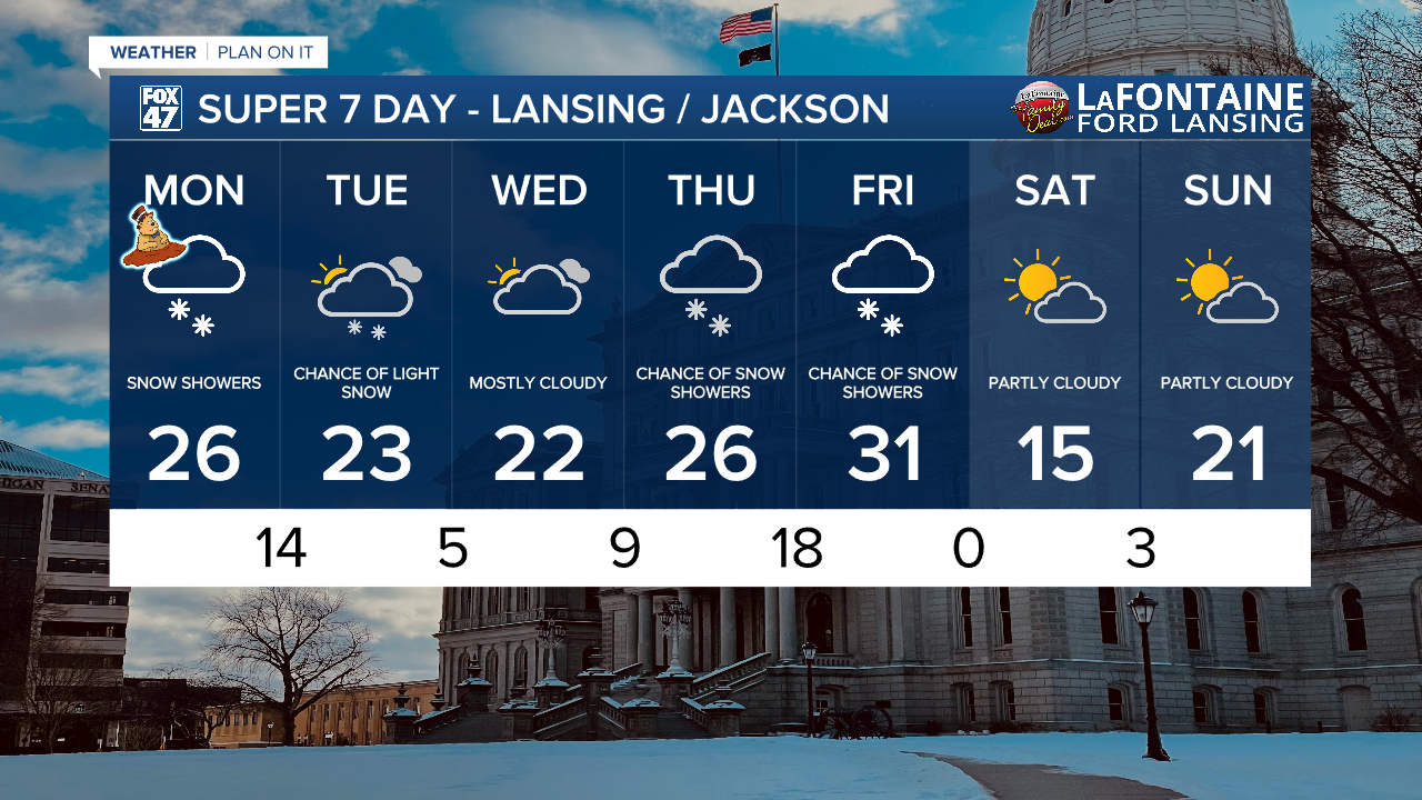
An advancing shortwave drives snowfall across our neighborhoods this morning which will last through about noon today. Accumulations will remain light as snowfall intensity weakens gradually as it tracks east. We are expecting up to an inch of snowfall by the time we reach noon with light additional snow expected this afternoon and into Tuesday morning. Impacts should stay minor today as salt will be effective in curing roadways of any snow and ice.

Winds will gradually shift out of the north once we start Tuesday with wind speed remaining not much of an issue.
February 2nd also marks Groundhog Day. As we watch for Punxsutawney Phil and his prognostication over in Pennsylvania, we are also watching closer to home for Woody the Woodchuck's forecast for a possible early spring or more winter. Wood the Woodchuck resides at the Howell Nature Center in Livingston County and since 1999 has favored 6 more weeks of winter predictions than early spring predictions. Below is Woody's past ten years of predictions.
Light snow and even some possible freezing drizzle continue through the afternoon and overnight tonight. We will take a break Wednesday with mostly cloudy skies and another round of snow arrives Thursday PM and into Friday. We will be monitoring closely.
Want more FOX 47 News? Here's how you download our Roku app
You can also see the latest news from across our mid-Michigan neighborhoods by liking us on Facebook or following us on X.
