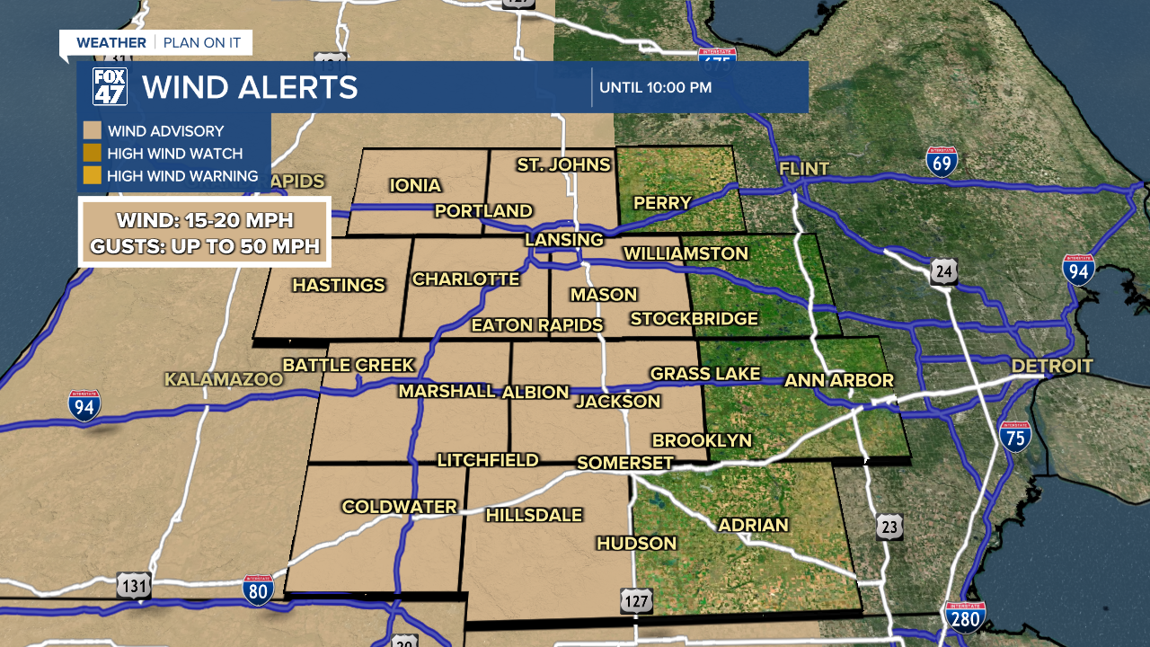
Weather

Actions

Showers & storms to start the week across Mid-Michigan followed by a stretch of below average temps

Highs range from the upper 60's to lower 70's today as showers and storms arrive later in the afternoon and evening hours with an isolated severe storm possible
Posted

LANSING, Mich. — Cloud cover increases gradually this morning with no other major impacts expected for the Monday morning commute. Temperatures this morning are ranging in the mid to upper 40's with feels like temperatures in the lower 40's. You might want to grab a jacket when heading out the door today.

Temperatures will warm back to the upper 60's/lower 70's today as winds out of the south continues and a late in the day warm front advances through our neighborhoods. Ahead of that warm front, surface moisture won't be as present compared to the end of last week, meaning it will feel a bit more comfortable outside today. Our best moisture arrives in the evening hours paired with storm potential that could bring some isolated severe impacts.

Showers and storms late this evening could produce severe wind gusts up to 60 mph and heavy rainfall rates with cooler air to follow

WATCH THE FULL FORECAST BELOW

Showers & storms to start the week across Mid-Michigan followed by a stretch of below average temps

We will stay dry with an abundance of clouds through the mid afternoon hours. We could see a few scattered showers as early as 4 PM with no major impacts expected other than some strong winds that could gust past 40 mph out of the south.

Strong winds gusting past 40 mph expected across our neighborhoods along with showers as early as 4 PM Monday

Strong winds will continue past midnight and weaken once the incoming cold front advances through our neighborhoods. We will stay breezy for the majority of Tuesday with gusts up to 30 mph out of the west gradually weakening during the afternoon hours.

We pair these strong winds with showers and storms from 8 PM to about 1 AM Monday night. It is during this period that the warm front will advances through our neighborhoods and stronger storms could develop. Our main hindrance is the lack of ample instability, a key thunderstorm ingredient.

A marginal risk for isolated severe storms exists for the majority of Hillsdale County and southwest portions of Jackson and Eaton counties for potential damaging winds gusts up to 60 mph. This would occur after 8 PM tonight with heavy rainfall rates leading to localized ponding also possible.

Isolated severe storms possible this evening across the majority of Hillsdale County and portions of Jackson and Eaton counties

We will turn our attention following the storm threat tonight to our cooling temperatures. We should still be able to see near normal highs Tuesday in the upper 50's/lower 60's. However, once Wednesday night arrives, we will be watching closely for conditions near freezing which could impact sensitive vegetation. Lows in the mid to lower 30's will continue Wednesday night through Sunday morning with frost possible depending on our cloud cover and wind coverage. If you have any early spring flowers or other vegetation, prepare to cover or bring your plants inside during this period.

We are continuing to forecast below average temperatures as we head further into the month of May as well. The final average frost for Lansing in spring occurs on May 7th. Across our neighborhoods the average final frost occurs between May 3rd and May 10th.

Cooler than average temperatures expected this week and as we head further into May
Cooler than average temperatures expected this week and as we head further into May with Lansing's average final frost occurring May 7th

Some remnant showers remain possible Tuesday morning with low impacts with some sunshine possible during the mid to late afternoon hours. A few tame light rain showers could develop Wednesday and Thursday with mostly cloudy skies. Some better chances to see some sunshine will arrive late this week and into the weekend where highs cool into the 50's.

7-Day Forecast 04/27/26
Following the storm threat this evening, remnant showers remain possible Tuesday morning with low impact shower chances midweek as temperatures gradually fall with overnight lows nearing freezing

Have a great weather picture or video to share? Send it our way and we may feature it on-air or online!

FOX47 Weather Web Submission