
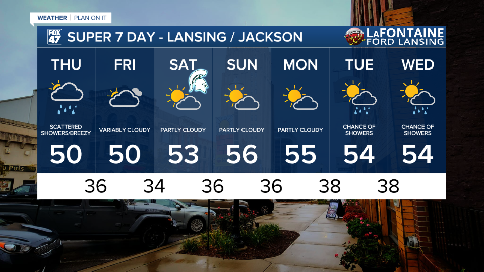
LANSING, Mich. — Lansing observed just over .2" of rainfall yesterday as we continued to see lake effect rain showers. This pattern will continue today as showers come to an end past 8 PM tonight.
High temps will continue to struggle to reach 50 degrees today across our neighborhoods with winds out of the north bringing cooler air into our neighborhoods. These daytime highs are below average for this time of year and we will continue to remain cool once we enter the weekend period.

WATCH THE FULL FORECAST BELOW
As the low tracks east, a lot of the more uniform areas of showers will stay a bit further west. Scattered showers will not produce a lot in the way of impacts today as they taper off past 8 PM Thursday night. We will be left behind with cloud cover and cold conditions as surface high pressure starts to build in.

With this area of high pressure, we will dry up for the weekend duration and see partly cloudy skies with weaker winds. Temperatures will remain chilly, however, with highs only warming into the mid 50's and lows remaining in the mid to upper 30's allowing for areas of frost.
Winds are gradually weakening as well now that the low is tracking east and out of the way. Gusts could reach up to 30 mph today as Lansing met a max wind gust Wednesday at 35 mph. Feels like temperatures could drop this afternoon into the lower 40's. Make sure you're bringing a jacket and umbrella when heading out the door today.

We dry up this weekend with chilly temperatures continuing in the overnight and morning hours. We will see partly cloudy skies Saturday with highs in the mid 50's. It would be best to bring a jacket if headed out to the Michigan State vs Michigan game at Spartan Stadium.
Highs remain in the mid 50's through midweek next week with returning chances for showers Tuesday and Wednesday. It is a bit early to talk details, but we will keep a close eye on it.
Want more FOX 47 News? Here's how you download our Roku app
You can also see the latest news from across our mid-Michigan neighborhoods by liking us on Facebook or following us on X.
