
LANSING, Mich. — We have a mild start to our Thursday across Mid-Michigan as winds out of the south continue to keep us warm in the upper 40's/lower 50's. Highs were able to reach the mid to lower 60's across all of our neighborhoods yesterday as sunshine was able to peak out in the late afternoon hours.
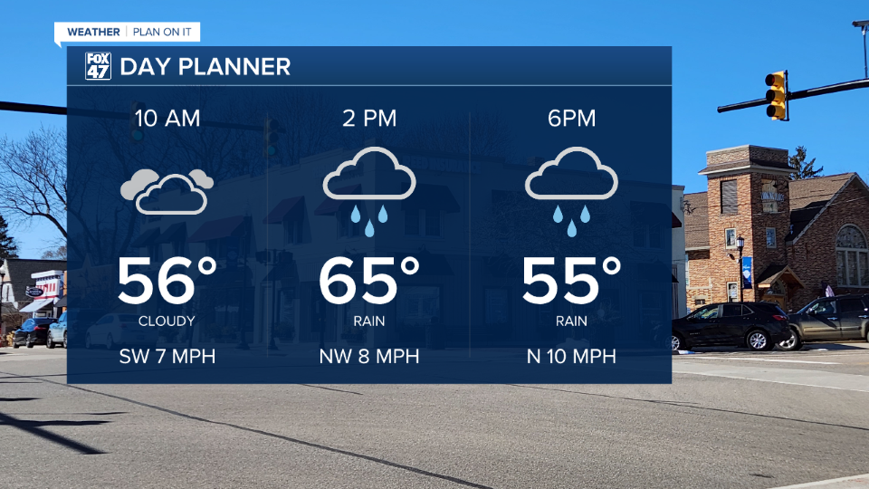
Sunshine will still remain possible through 2 PM this afternoon as temperatures warm into the mid 60's in Lansing. After 2 PM, we will start to see showers and storms develop across our neighborhoods with potential severe impacts taking us into the evening hours.
WATCH THE FULL FORECAST BELOW
The Storm Prediction Center has continued the slight risk for scattered severe thunderstorms across southern neighborhoods in all of Jackson and Hillsdale counties today with a marginal risk for isolated severe storms across our northern neighborhoods of Eaton, Ingham, and the southern half of Clinton counties. All impacts are still at play, however, the tornado threat has shifted south focused more towards an isolated tornado threat for Hillsdale County.
Damaging wind gusts remain a possible impacts across all neighborhoods while we also hang onto the hail threat which could produce hailstones as large as 2" in diameter and possible larger.

Timing for showers and storms to arrive begins around 2 PM as the cold front continues its track south through our neighborhoods. From 2 PM to 4 PM showers and storms should remain non-severe and focused more towards northern neighborhoods. Storms following 5 PM heading towards our southern neighborhoods have the better chance to turn severe. These impacts will last through about 11 PM this evening.

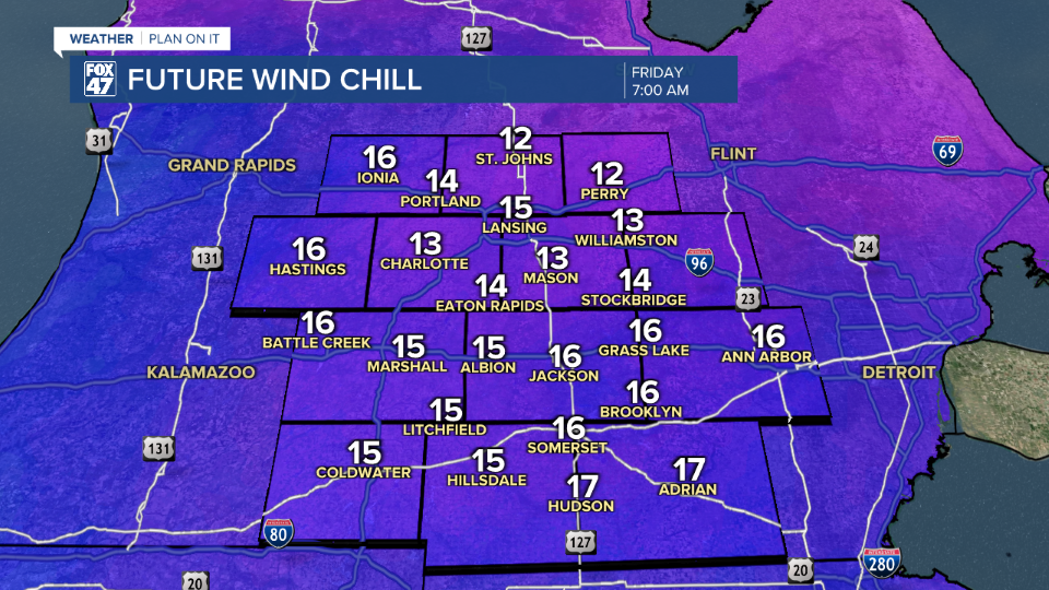
Winds turn out of the north and remain breezy with gusts up to 30 mph through Friday morning. We will need the winter jacket heading out the door Friday morning as well as some possible hat and gloves. Temperatures overnight fall into the upper 20's with feels like temperatures in the mid teens.
Daytime highs will also fall below average, struggling to reach 40 degrees on Friday. We will gradually warm into the weekend with highs in the upper 50's by Sunday. We are tracking lots of sunshine possible this weekend as well which will at least make outside look nicer than how it will feel. Temperatures return to the 60's to start the new week Monday. However, tame showers remain possible Monday with thunderstorm potential renewed Tuesday and Wednesday. It's too early to talk severe potential, but have those umbrellas ready next week.

Have a great weather picture or video to share? Send it our way and we may feature it on-air or online!

