
LANSING, Mich. — After enjoying the past two days filled with sunshine, cloud cover will increase Thursday morning ahead of scattered rain showers. A strong upper level low is responsible for bringing this rainfall back to our neighborhoods with daytime highs warming well above average into the mid to upper 40's.
These warm temperatures and returning rainfall will allow for moderate to significant snow melt across our neighborhoods. Today. Sycamore Creek in Holt is expected to reach Action Stage Friday morning due to runoff and our chances for a green Christmas are a bit more elevated as temperatures continue to trend on the warm side with not a lot of snowfall in the forecast.

WATCH THE FULL FORECAST BELOW
We could see scattered showers begin as early as 10 AM Thursday morning. Winds will gradually strengthen ahead of an incoming cold front.
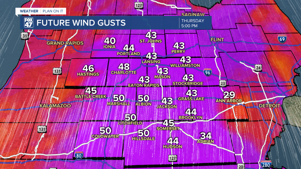
We will see our strongest winds around 5 PM Thursday evening with gusts potentially exceeding 45 mph. Paired with heavier precipitation rates, the evening commute could bring limited visibility. Rainfall totals could range from .25" to .5"

Once the cold front advances through, we will cool rapidly with strong winds renewed out of the northwest as a lake effect snow setup takes place. The main concern in this rapid cooling is the potential for wet roadways to freeze overnight, allowing for slick spots on roadways for the Friday morning commute.
On the snow side, we are not looking at any major accumulations. All of our neighborhoods could see around an inch of accumulation by the time we reach the early afternoon hours Friday.

Temps drop into the upper 20's Friday with a rebound occurring Saturday as another clipper could bring rain and snow to our neighborhoods with highs in the upper 30's.
Above average temperatures are expected as we inch closer to the holidays where we will be watching for a potentially green Christmas.

Want more FOX 47 News? Here's how you download our Roku app
You can also see the latest news from across our mid-Michigan neighborhoods by liking us on Facebook or following us on X.
