


LANSING, Mich. — Confidence is building for a potential major winter storm to impact Michigan just ahead of the Christmas holiday. Blizzard conditions are possible across much of the state with nearly impossible travel.
There are still some details to iron-out with this system, but models are in unusually high agreement this far out. Still, remember that changes to the forecast can happen as we get closer to the storm actually moving into Michigan.
That being said, it is time to consider a plan B if you are traveling for the Christmas holiday weekend. A flash freeze, high winds, heavy snow, and bitter cold will make travel treacherous if not impossible across much of the area.
The storm system will undergo "bombogenesis." That's when the pressure drops 24 millibars in 24 hours. It basically means a rapidly strengthening storm or "explosive" development. Many models are indicating that 24 millibar drop in pressure in about half the time required to be considered a "bomb cyclone."
Thursday we will have a wintry mix across the area. Some of us could switch between rain, snow, and freezing rain several times as moisture surges north from the Gulf of Mexico. Travel might already be dicing starting then. Winds will steadily increase Thursday into Friday as the storm continues to gather strength. An area of intense warmth and moisture will wrap into the middle of the storm. This is called a "trowal." If its cold enough for this to be snow, it'll fall very heavily.
Most models have the low pressure sitting over Michigan Thursday night into Friday gathering even more strength. A brief round of rain will lift through with temps in the 30s. This will be followed by a wall of cold air that will drop us to around 10 degrees or colder in mere hours. A flash freeze of water on roads is expected.
Once the flash freeze occurs, expect heavy snow to move in with high winds. Blizzard conditions and extreme cold are likely. Snow will be blinding with white out conditions. Cold temperatures and wind chill values as cold as double digits below zero will create life-threatening conditions for those who may get stranded. Please avoid travel.
Heavy snow last into Christmas Eve with conditions slowly tapering off through the day. High winds will remain and continue to blow the snow around. Lake effect snow will kick in and continue to cause travel woes.
Christmas Day will feature cold temperatures and gusty winds. Some areas might continue to see lake effect snow accumulate.
It's too early for official snow totals, but they could be significant. Also, regardless of how much snow you get, travel will be awful. The snow will be blowing around in our high winds anyway, so, official totals might not really matter.
European model possible snow:

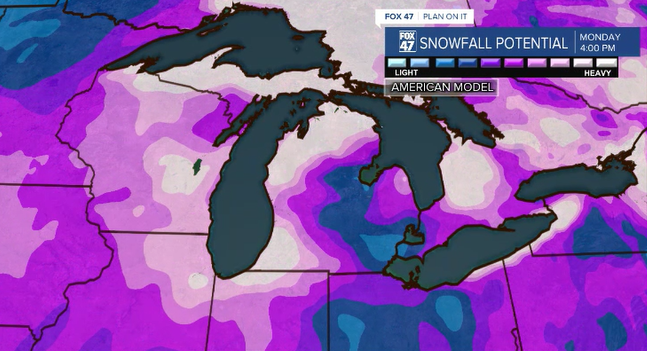
American model possible snow:
It's time to have a plan B, but don't implement it just yet. Let's watch as the storm gets a bit closer.
Here is how snow forecasting generally works:
5-7 days out: We're watching model trends. You should do nothing.
3-5 days out: Something is heading our way. We still need to figure out track, timing, moisture, snow totals. You can start thinking about the chance it actually happens.
2-3 days out: We have a pretty good idea it'll happen. Fine details, specific snow totals, specific timing can vary a bit. You should have a plan, prepare, and watch for changes to the forecast.
1-2 days out: We are finalizing our forecast and communicating any uncertainties that remain. You should be prepared and start implementing your plan.
0-24hrs out: We are in "tracking mode" forecast is usually finalized. You should have implemented your plan, made preparations, and wait it out.
Want to learn more about the Weather? Visit the FOX47News Website.
Stay in touch with us anytime, anywhere.
Sign up for newsletters emailed to your inbox.
Select from these options: Breaking News, Severe Weather, School Closings, Daily Headlines and Daily Forecasts.
