
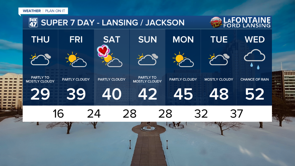
LANSING, Mich. — Temperatures were able to warm into the mid 30's yesterday with chilly conditions continuing due to present winds and dropped wind chills. Today, winds will will stay weakened as high pressure builds into the region. Temperatures trends will remain in the upper 20's/lower 30's for a lot of our neighborhoods making it feel a bit warmer.

WATCH THE FULL FORECAST BELOW
We will start the day with partly cloudy skies and some possible sunshine as cloud cover will gradually filter in during the afternoon hours. More sunshine is expected in our forecast as we close our week on Friday with partly cloudy skies and temperatures continuing to warm into the upper 30's. We could possible even see some neighborhoods reach the 40's again.
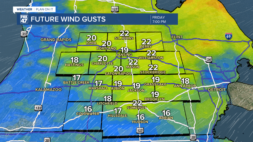
Wind speeds, however, Friday will pick back up gusting as high as 20 mph out of the southwest aiding in the warm up which will take us into next week. No wind impacts are expected Friday and we will be feeling a lot warmer as we enter our weekend with renewed partly cloudy skies on Saturday for Valentine"s Day and temperatures warming into the 40's.
The chance for rain and snow on Sunday has been dropped and we will continue to monitor closely for any additional changes. We are now looking at partly to mostly cloudy skies that day with temperatures continuing to warm.
This warm up will aid in melting our snow pack which has already been occurring following warmer temperatures and sun from earlier this month. However, temperatures are expected to stay above freezing through midweek next week. Melted snowfall which runs off into cracks in roads could create more pot hole issues if we do freeze back below freezing.
We stay dry to start next week with returning precipitation in the form of rainfall possible on Wednesday.
Want more FOX 47 News? Here's how you download our Roku app
You can also see the latest news from across our mid-Michigan neighborhoods by liking us on Facebook or following us on X.
