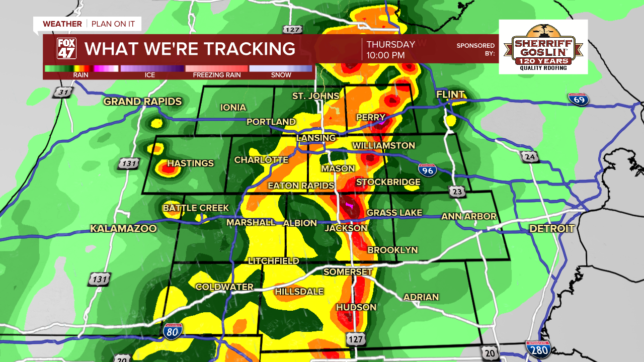
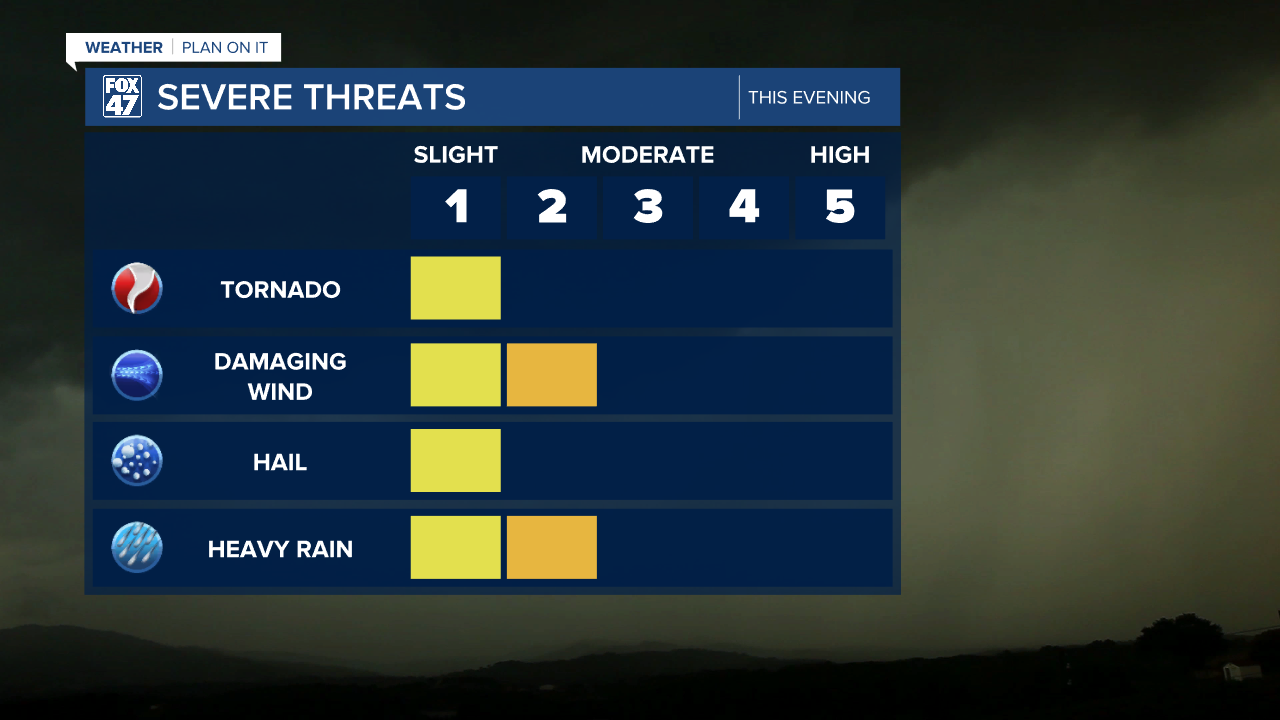
Weather

Actions

Active weather pattern across Mid-Michigan Thursday with freezing rain and potential severe storms

Freezing rain could worsen road conditions this morning while damaging winds remains the main threat with tonight's round of storms
Posted
and last updated

LANSING, Mich. — We are tracking showers ahead of an incoming warm front Thursday morning across our neighborhoods. Temperatures have been hovering around and just above freezing allowing for the risk for freezing drizzle. Our neighborhoods along and north of I-96 including Clinton County and most northern neighborhoods of Eaton County could see some of this mix from 6 AM to 9 AM this morning with dicey road conditions possible.

As we continue to warm throughout the morning, precipitation mixes to all rain with some rumbles of thunder possible as we head into the late morning hours just ahead of the warm frontal passage. No severe impacts are expected during the morning hours, but you could find yourself in areas of heavy rain and strong winds. Make sure to grab the umbrella when heading out the door Thursday morning.

Freezing drizzle could lead to slick spots during the Thursday morning commute in areas along and north of I-96

WATCH THE FULL FORECAST BELOW

Freezing drizzle this morning to potential severe storms this evening across Mid-Michigan

Showers and tame thunderstorms come to an end around noon Thursday as the warm front will advance through our neighborhoods shifting winds out of the south. These southerly oriented winds will aid in rapid warming with highs expecting to reach the upper 60's later this evening past sunset. These southerly winds will also bring moisture back to our neighborhoods with dew points at the surface reaching the lower 60's.

Warm front advances north through our neighborhoods allows high temperatures into the upper 60's later Thursday evening

This transfer of moisture will aid in building an unstable air mass across all of our neighborhoods today aiding in fueling severe thunderstorm potential later on this evening. We are watching the time frames of 7 PM to 2 AM for severe impacts. The slight risk of scattered severe storms exists across all of our neighborhoods from the Storm Prediction Center with the primary threat being damaging winds possibly exceeding 60 mph. This could lead to power outages across our neighborhoods.

Damaging wind gusts exceeding 60 mph remains possible with thunderstorms Thursday evening across our neighborhoods

Other severe impacts affiliated with the thunderstorm threat include heavy rainfall rates that could lead to localized ponding in areas such as Lansing and Clinton County, and an isolated tornado threat. Hail cannot be ruled out either.

All severe threats remain possible Thursday evening across Mid-Michigan with primary threats including damaging winds and heavy rainfall

The timing for storms does line up with the Lansing Lugnuts home opener later this evening at Jackson Field with first pitch scheduled at 6:05 PM. There is a chance that the game could start off dry with breezy conditions with the thunderstorm threat increasing as the game continues. If heading out to the ballpark, bring an umbrella and have a plan for if you get caught up in severe storms.

Lansing Lugnuts home opener could be faced with showers and storms with severe potential Thursday evening
Watching for potential severe storms anytime after 7 PM Thursday evening with damaging winds as the main threat

We will dry up heading into the 4 AM hour overnight tonight with temperatures expected to stay mild through Saturday with highs in the 60's and overnight lows above freezing. The pattern changes Easter with chances for AM rain and snow continuing with no major disruption expected for the afternoon hours. Temperatures will drop into the 40's for daytime highs and back below freezing for overnight lows early next week.

7-Day Forecast 04/02/26
Temperatures stay in the 60's through Saturday with renewed showers and thunderstorms as Easter cools into the mid 40's with a chance for morning rain and snow showers

Have a great weather picture or video to share? Send it our way and we may feature it on-air or online!

FOX47 Weather Web Submission