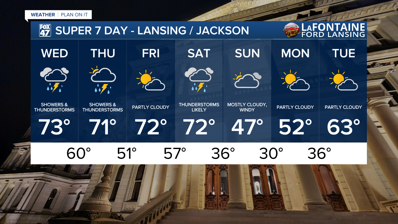
Weather

Actions

First round of storms comes to an end across Mid-Michigan as another round arrives later Tuesday night

As we continue to build instability with continued transfer of warm moist air from the south, we will also be tracking several disturbances allowing for storm development
Posted
and last updated

10 AM UPDATE

The Storm Prediction Center has upgraded the severe weather outlook to include an enhanced risk for severe storms across almost all of our neighborhoods for thunderstorms advancing through Tuesday night. We are watching the time frames of 8 PM to 3 AM.

Enhanced risk for severe storms across Mid-Michigan Tuesday night

Both the tornado threat and wind threat have been upgraded across almost all of our neighborhoods. The tornado threat remains isolated with winds, hail, and flash flooding remaining as our main concerns overnight tonight. Make sure to have ways to get updates and alerts.

Tornado threat upgraded across our neighborhoods for Tuesday night storms
Severe wind threat upgraded across our neighborhoods for Tuesday night storms

In addition to the SPC upgrade, the National Weather Service has also issued a Flood Watch for all of our neighborhoods except Hillsdale County. This watch will go into effect at 8 PM Tuesday evening and last through late Thursday night at 2 AM Friday.

Flooding from excessive rainfall could lead to impacted roadways as well as runoff flooding local river sites. Make sure not to drive through flooded water and to make sure your gutters are clear.

Flood Watch issued across Michigan in effect at 8 PM Tuesday evening

Also, send any of your weather video, photos, or reports to us!

FOX47 Weather Web Graphic

ORIGINAL POST

Make sure to have the rain gear ready again today as we are waking up to strong thunderstorms moving across the state of Michigan. A lot of the severe impacts have been observed a bit further north along the stalled out frontal passage, but wind gusts up to 50 mph are still possible along a line of storms tracking through our neighborhoods through around 6:30 AM. Stay weather aware on those roads as we will see the end of this first round of storms by 10 AM.

We will remain south of the stalled out surface frontal passage today allowing for southwesterly winds to keep warm and moist conditions around. We can expect high temperatures into the upper 70's again today.

Still feeling like summer today across our neighborhoods with highs in the upper 70's ahead of another round of storms

WATCH THE FULL FORECAST BELOW

First round of storms comes to an end across Mid-Michigan as another round arrives later Tuesday night

An incoming low riding along the stalled out frontal passage will aid in thunderstorm development again Tuesday night across our neighborhoods. Our environment will be prone to severe impacts again as we rebuild instability due to continued transfer of moisture out of the south.

We stay south of the stalled out surface front with areas of low pressure riding along the front aiding in thunderstorm development during the first half of this week

The Storm Prediction Center continues to include all of our neighborhoods in a Slight risk for scattered severe storms Tuesday night. Primary severe impacts include damaging winds in excess of 60 mph and possible large hail. The tornado threat remains isolated with this round of severe weather.

Slight risk for scattered severe thunderstorms exists across all of our neighborhoods
Severe Threats for Tuesday night's severe potential

Another important impact to watch out for is heavy rainfall that could lead to flash flooding concerns. A slight risk for excessive rainfall has been issued across neighborhoods along and north of I-94. A marginal risk exists for all neighborhoods south of I-94. Flash flooding and localized ponding remains possible with these storms.

We could see thunderstorms develop anywhere at or after 6 PM Tuesday. There is a chance that these storms could persevere into the overnight hours similar to how the first round of storms behaved into Monday morning. Looking at our forecast satellite and radar, we could see storms with severe impacts roll through past midnight tonight. Make sure to have a way to get alerts when heading to bed this evening.

Our next round of potential severe storms occurs after 6 PM Tuesday and potentially lasts into the overnight hours

We will continue to track showers and storms Wednesday and Thursday with severe impacts possible. However, the severe potential does depend on when this second round of storms advances through our neighborhoods and whether we are able to destabilize efficiently in regards to the tornado threat. These storms also look to arrive late Wednesday evening and possibly last into the overnight hours.

We will dry up on Friday and keep the warmer temperatures in the 70's before cooling down late this weekend with temperatures possibly returning below freezing.

7-Day Forecast 04/14/26
Showers and storms continue across our neighborhoods during the majority of the work week with temperatures feeling more like summer as we begin to cool down late this weekend

Have a great weather picture or video to share? Send it our way and we may feature it on-air or online!

FOX47 Weather Web Submission