
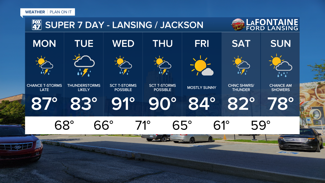
LANSING, Mich. — After a pleasant weekend across Mid-Michigan, we will be tracking a busy week filled with extreme heat, thunderstorms, and humid conditions.
Monday brings dry conditions during the daytime hours with increasing cloud cover through the day. A few peaks of sunshine will still remain possible. Temperatures will warm into the mid to upper 80's which is well above average for this time of year. Winds will remain weak today making today the best day to get outside and accomplish any outdoor activities before showers and storms return to the area

WATCH THE FULL FORECAST BELOW
At the surface, an incoming warm front will aid in shower and thunderstorm development across Mid-Michigan. Our area will see these showers and potential storms around 11 PM tonight where weak shear makes severe potential low. However, heavy rainfall rates and breezy conditions remain possible. As we head later into the overnight hours, the more we lose instability. We do have a chance to see just showers during this overnight period. Make sure to keep the windows closed. Overnight lows during this time will remain hot only cooling to the upper 60's.

More thunderstorms develop throughout the daytime hours Tuesday with no severe impacts expected. We could see, however, heavier rainfall rates and gusty winds possibly exceeding 30 mph. Make sure to have the umbrella ready. The warm front will advance through the area during the PM hours. This will allow for warmer air to usher into Michigan with extreme heat becoming an impact beginning Wednesday.

We are expecting daytime highs Wednesday and Thursday to reach the lower 90's. This is well above average for this time of year and heat index values could reach the mid to upper 90's which could also allow for heat related illness. Make sure to stay hydrated during this time and limit time outdoors. We do have chances to see thunderstorms during the day Wednesday and Thursday, but with ample instability, our best chance for severe weather arrives during the late and overnight hours Wednesday into Thursday and Thursday into Friday.

We will remain uncomfortable during this time as well during the daytime hours with dew points expecting to reach the upper 60's and possibly 70's. This moisture will make the outdoors feel very uncomfortable. Try to limit time outdoors this week if you can and dress for the heat. We will see some improvements heading into the weekend.

We will dry up for most of the day Friday with sunshine expected to return with temperatures gradually cooling to the lower 80's by Saturday and into the upper 70's by Sunday. Another system could bring some thunderstorms late Saturday, however, we could still see a lot of changes to this forecast as we continue through the week. We will be monitoring closely.
Have a great weather picture or video to share? Send it our way and we may feature it on-air or online!

