
LANSING, Mich. — We are starting a new week chilly across our neighborhoods with temperatures Monday morning below freezing in the mid to upper 20's. This is well below average for this time of year as overnight lows should be ranging in the upper 30's. This isn't out of the ordinary in Michigan, however.
A Freeze Warning remains in effect across all of our neighborhoods through 11 AM Monday morning.

WATCH THE FULL FORECAST BELOW
If you have cold season plants you are tending to, make sure to keep them safe during freezing events as a lot of these colder season plants can only withstand light frost and not a harsh freeze. The good news is we will see much warmer temperatures across our neighborhoods starting Tuesday.
For now, we can expect high temperatures to climb to the upper 40's with weak winds as surface high pressure advances through our neighborhoods. This means we we will also see lots of sunshine today across our neighborhoods.

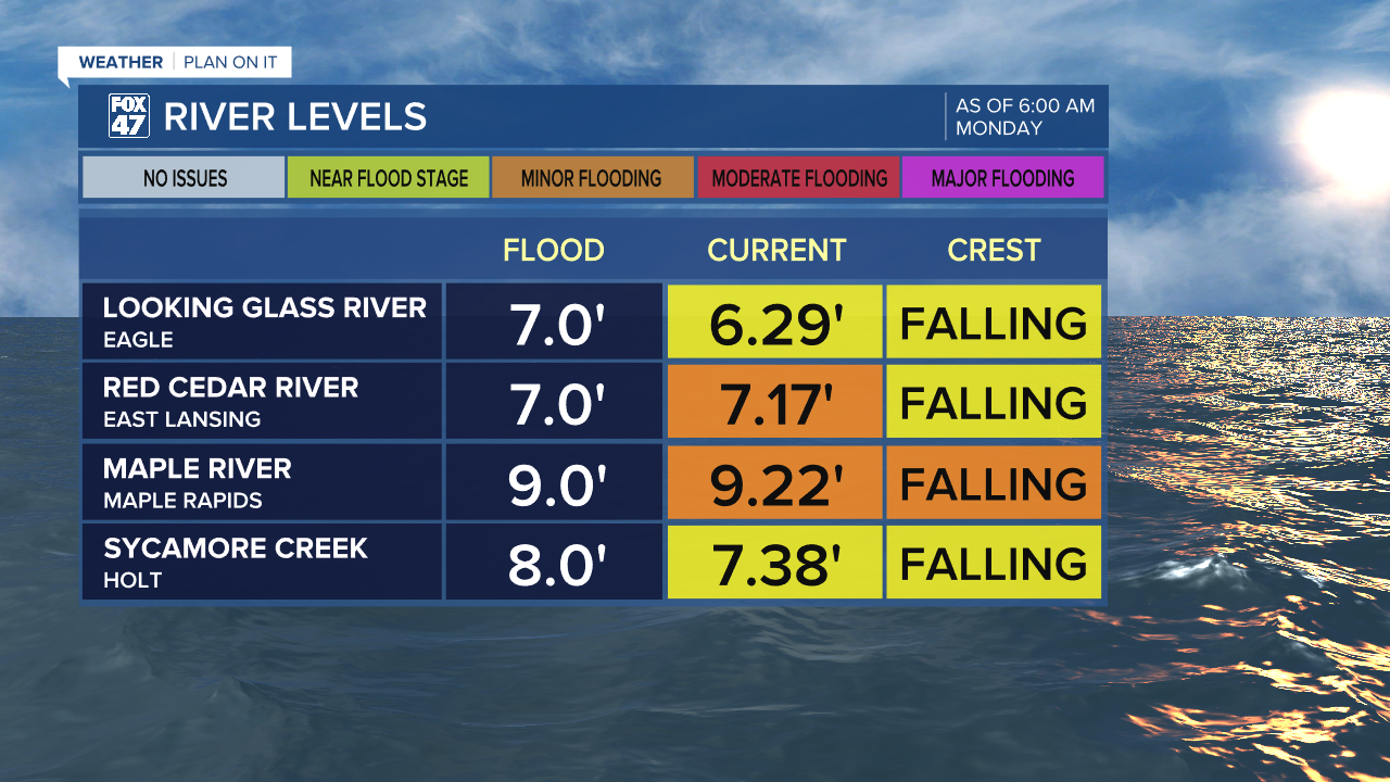
Even with all of this sunshine and dry conditions, flood warnings continue on for a few local river sites as the Red Cedar River in East Lansing and Maple River in Maple Rapids currently lie in minor flood stage. Both of these sites are falling slowly as we continue to see improvements following last week's showers and storms. Below you can see an update of local river levels.
Tuesday brings more sunshine during the first half of the day as an incoming warm front will aid in warming temperatures and building instability for storm development Tuesday evening. We are watching the time frames from 8 PM Tuesday to 2 AM Wednesday for tame thunderstorms to track south through our neighborhoods, mainly focused along and south of the I-94 corridor, but there is a chance neighborhoods along and south of I-96 could see some action as well.
These storms should stay non-severe, but we could see some steady rainfall rates and stronger wind gusts. Make sure to pack the umbrella when heading out the door for any Tuesday evening plans.

We will enter Wednesday with more sunshine and temperatures into the upper 60's, similar to Tuesday. Thursday brings our warmest temperatures of the week in the mid 70's with a stray shower possible across our neighborhoods. Friday brings the better chance for showers and thunderstorms. We will dry up heading into the weekend with cooling temperatures.

Have a great weather picture or video to share? Send it our way and we may feature it on-air or online!

