
LANSING, Mich. — Conditions will go downhill rapidly overnight into Friday morning. Everyone has the possibility for prolonged white out conditions into the weekend. Many will top a foot of snow accumulation.
Anyone in the FOX47 viewing area needs to be hunkered down and off the roads. The road conditions will go downhill very quickly through the rest of Thursday night and into Friday.
Thankfully even though heavy snow begins, the cold air and wind wont arrive until about 9-11pm Thursday evening. After that, blizzard conditions are likely through the rest of the night and through Friday. Visibility will be near zero at times thanks to 55mph wind gusts blowing around the powdery snow. Please do not travel at all Thursday night through Friday night unless it is absolutely necessary.
Temperatures will be extremely cold Friday. They will fall into the single digits which means salt treatments on the roads won't work. Anything that was wet Thursday evening will be a sheet of ice by Friday morning. Then, add the blizzard conditions on top of it. Travel is downright NOT recommended.
Many of us will already see over half a foot of snow by daybreak Friday and potentially over a foot by Saturday morning. A few localized area could exceed 15" just by Saturday night. With more lake effect through Sunday and maybe even Monday, totals could go even higher.

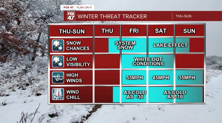
But it's not so much the snow as it is the white outs, extreme cold, and power outages that will cause the most harm. Here is a breakdown of the different threats and the timing of each:
A Winter Storm Warning has been issued for the FOX 47 News viewing area from 4pm Thursday through 1am Saturday. The Blizzard Warning to the west is issued from 4pm Thursday through 7pm Saturday. My thinking right now is that once the Winter Storm Warning expires, we'll be issued an additional Winter Weather Advisory that will carry us through Christmas from lingering blowing snow and lake effect.

Please remember that generators need to be outside and well ventilated. Do not run a generator in the basement or the garage. People have died from carbon monoxide as a result of doing that.
Road conditions could start to improve by Saturday evening, but they won't be perfect. Many areas will still experience bad blowing and drifting. Sunday will be a little bit better, but things won't be "business as usual" again until perhaps Monday.
Please stay safe and check back for frequent updates. I (Chief Meteorologist Brad Sugden) will be working around the clock through the entire weekend to keep you updated. In addition to being live on the air during the blizzard, I'll be doing frequent Facebook live updates on my page. Search Facebook for "Meteorologist Brad Sugden."
Want to see more local news? Visit the FOX47News Website.
For more news in your neighborhood, go to our In Your Neighborhood page on our website.
Stay in touch with us anytime, anywhere.
Sign up for newsletters emailed to your inbox.
Select from these options: Neighborhood News, Breaking News, Severe Weather, School Closings, Daily Headlines, and Daily Forecasts.
