


LANSING, Mich. — Thoughts of pumpkins, sweaters, jeans and apple cider will be on hold for a while. Mother Nature says summer is going to get every day it deserves this year. Even though fall has started for meteorologists and our record keeping, it appears summer will follow the cosmos in 2022. The start of fall based on the Earth's orbit, the equinox, will be Sept. 22 - the day we might cool down.

We've enjoyed the taste of fall over the weekend and Monday, now we're cranking that heat back up. Expect some of us to near 90 degrees by next week. Why is this happening? Well, a weather system from Asia is partly to blame.
Yes, Asia. That continent half a planet away will affect our temperatures here in The Mitten. As a powerful storm system leaves the other side of the world, it moves over the pacific and eventually over the western shoreline of the United States. As this happened, a very deep dip in the jet stream will occur out west. For us that means the jet stream rises very far to the north. We can this "ridging." You may think it sounds familiar because meteorologists will often say, "a ridge of high pressure is moving in."
When the jet stream shoots way up into Canada it pushed the cold air up that way as well. This allows a lot of heat to move up from the south with nothing to get in its way. The other issue is this pattern gets locked in for the better part of 5-7 days. Each day will be hotter and hotter until finally a cold front blasts on through. The position of a high and low pressure in association with the jet stream will work in tandem to bring us a southwest wind and hot air. Think of them rotating like two gears in sync.

Eventually this pattern will break down, but that depends on the strength of the ridge, the jet stream, and the area of high pressure.
One way we can get and idea this far away is by looking at many models and seeing if they average together nicely, or if they're all over the place. We call these "ensemble" models. The picture below looks super complicated, but it doesn't have to be. If all the models are in agreement and show close to the same outcome, we know there's a pretty good shot that is what will happen. If the models show results that are widely different, we know we need to wait until it closer for better data.
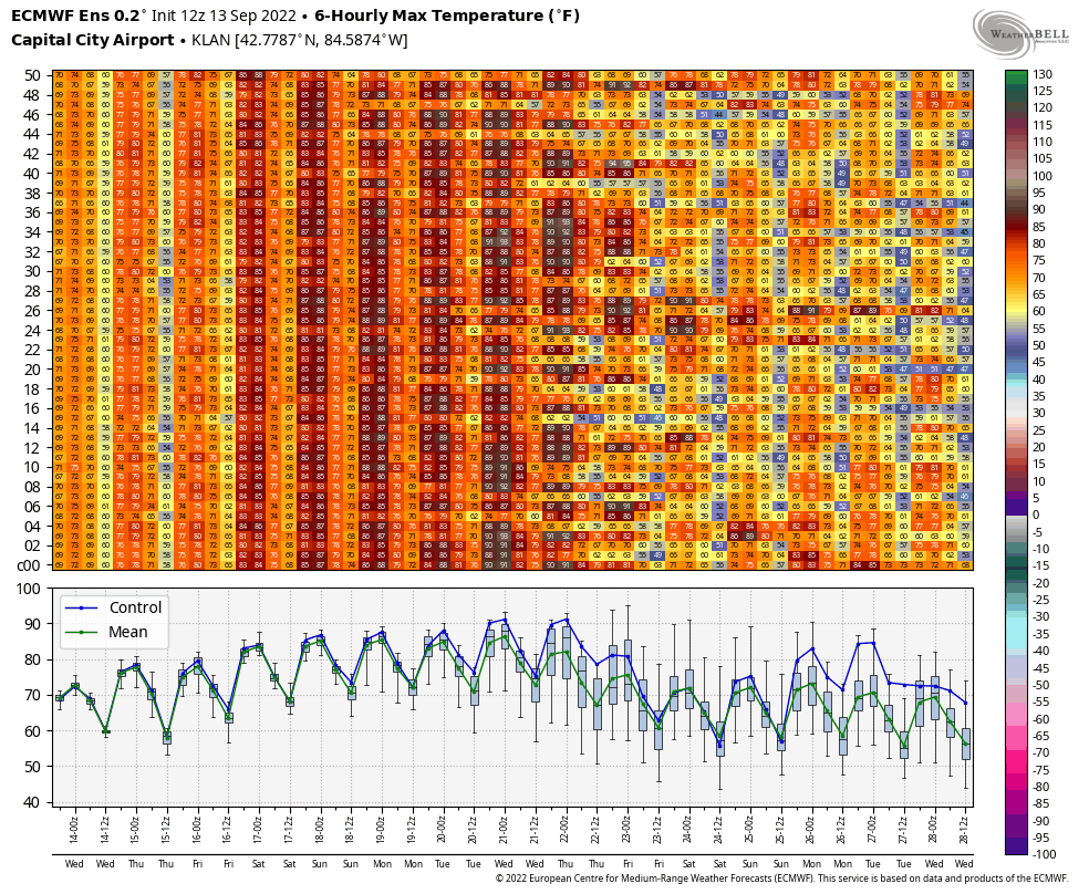
Basically, you can see they all indicate hot days - many of them. However, about halfway through, some keep us hot while others take us back down to average temperatures. This means the heat will for sure last for about six days, maybe as long as eight. This is because the model output is more irregular than consistent. We'll have to wait until the storm system and jet stream patterns are closer.
Either way, don't take those window A/C units out just yet. Don't drain that pool just yet either. The heat is on!
Want to see more local news? Visit the FOX47News Website.
For more news in your neighborhood, go to our In Your Neighborhood page on our website.
Stay in touch with us anytime, anywhere.
Sign up for newsletters emailed to your inbox.
Select from these options: Neighborhood News, Breaking News, Severe Weather, School Closings, Daily Headlines, and Daily Forecasts.
