

WIND ADVISORY remains in effect for all of Mid-Michigan until 7:00 AM Thursday.

WINTER STORM WARNING in effect for BARRY and CALHOUN Counties from 7:00 AM Wednesday until 7:00 PM Thursday, with a WINTER WEATHER ADVISORY in effect for EATON, IONIA, and JACKSON Counties.

Lake effect snow showers will continue overnight as low pressure moves east of the state. Some of the snow could be heavy at times, leading to snow-covered roads and reduced visibility. Temperatures will hold in the low 30s throughout the night, but winds will make it feel more like the upper teens to low 20s.

Conditions won't change much for Thanksgiving. Scattered lake effect snow showers will persist throughout the day as cold winds off of Lake Michigan remain in place. Expect westerly winds at 15-20 mph, with gusts still topping 35 mph at times. This will keep wind chills stuck in the same upper teens to low 20s, so make sure to layer up and use caution as you make your way to your Thanksgiving destination!

Snowfall expectations remain the same through Friday morning. Locations from St. Johns and Lansing to Ann Arbor will pick up 1-2" of snow from Wednesday through Friday morning. 2-4" is likely for neighborhoods from Ionia to Jackson and Hillsdale, with 4-8" or more along and west of I-69.
GET YOUR FOX 47 FORECAST HERE
Arctic air sticks around on Friday, but we get a break from the snow showers in the afternoon under mostly cloudy skies. Dress warmly if you're headed out for some Black Friday shopping as highs will remain stuck in the low 30s.

Highs stay in the 30s on Saturday and Sunday, with an increasing likelihood for a significant round of snowfall. Snow begins to spread into our area Saturday afternoon and will likely continue through most of Sunday. We'll begin to get a clearer picture once our current storm system moves out, but early signs point to at least 4" of snow for most of the region, with the potential for more. Stay tuned to Fox 47 for updates!
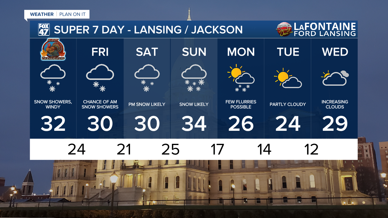
Another wave of Arctic air follows the weekend system, dropping highs into the 20s Monday through Wednesday. Aside from the chance for a few flurries on Monday, the first half of the week is generally looking dry.
Want more FOX 47 News? Here's how you download our Roku app
You can also see the latest news from across our mid-Michigan neighborhoods by liking us on Facebook or following us on X.
