
LANSING, Mich. — After a stretch of warm and pleasant weather, Mid-Michigan is entering a more active pattern that begins with scattered thunderstorms tonight, followed by a cooler Sunday and several opportunities for rain and storms during the middle of next week.
Scattered Strong Storms Possible Tonight
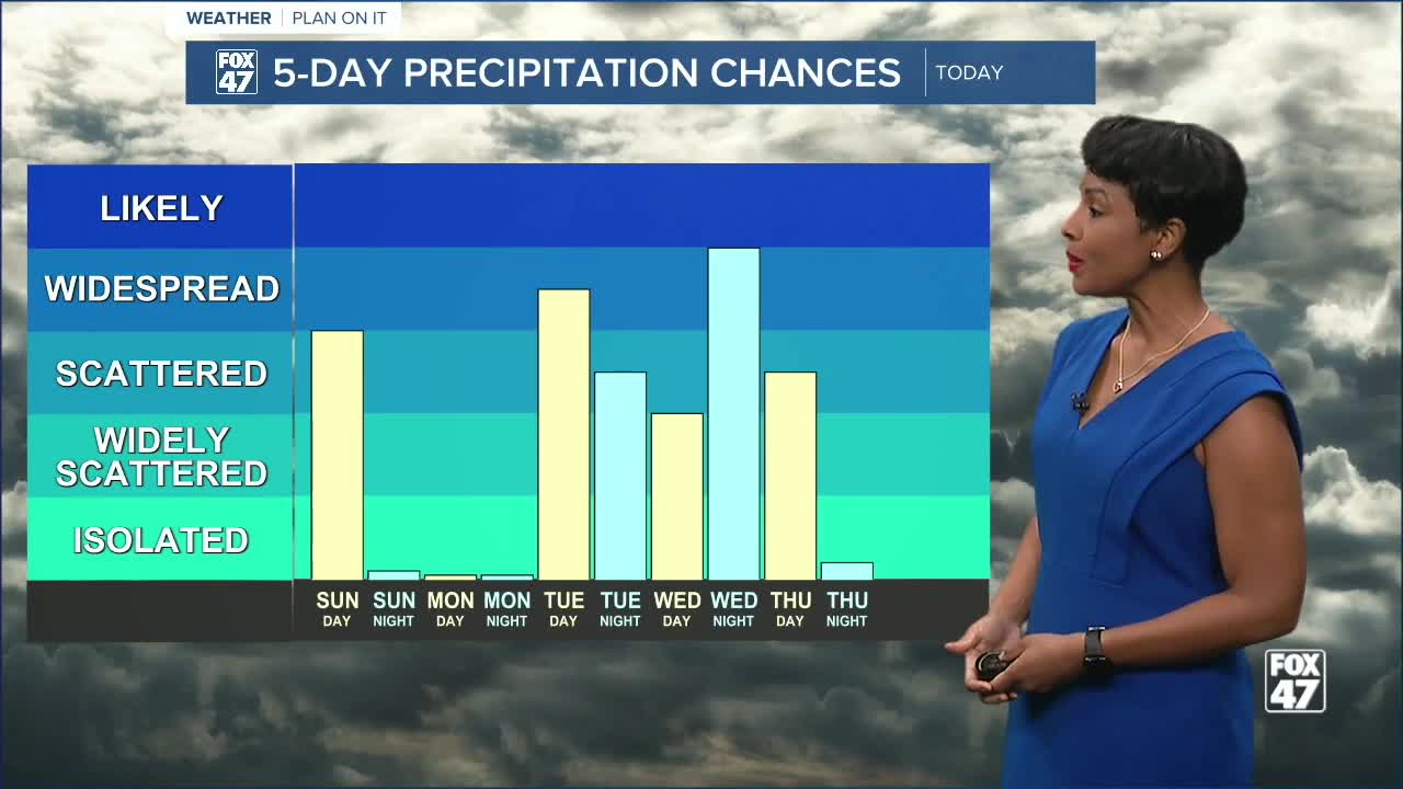
A cold front approaching Lower Michigan will interact with a favorable upper-level weather pattern to trigger scattered showers and thunderstorms this evening and overnight. While widespread severe weather is not expected, a few stronger storms could develop.
The primary threat will be gusty winds between 40 and 60 mph, especially where thunderstorms become more organized. Forecasters note that atmospheric conditions support some stronger wind gusts, although a layer of more stable air near the surface may limit how much of that wind reaches the ground.
In addition to strong winds, some storms could produce small hail, with isolated reports of quarter-sized hail possible. A brief, weak tornado cannot be completely ruled out across portions of southwest Michigan, but that threat remains very low.
Storm coverage is expected to be scattered rather than widespread, meaning some communities may see heavy rain and thunder while others receive little rainfall.
Cooler Sunday with Morning Showers
The cold front will be slow to exit the region overnight, allowing for showers and a few lingering thunderstorms Sunday morning. Conditions should gradually improve from west to east through the afternoon as drier air works into the state.
A northwest breeze will develop behind the front, with wind gusts reaching 20 to 30 mph at times.
Temperatures will also take a step back, with highs topping out near 70 degrees, several degrees cooler than recent days.
Sunshine Returns Monday
Monday looks to be the pick of the week, featuring mostly sunny skies and seasonable temperatures.
Highs are expected to reach the lower 70s, providing a brief break before another active stretch of weather arrives.
Storm Chances Return Tuesday
Rain and thunderstorm chances increase again Tuesday as another strong upper-level system approaches the Great Lakes.
Current forecast guidance suggests showers and thunderstorms will become increasingly likely Tuesday afternoon and evening, especially across central and eastern portions of Lower Michigan.
Some stronger storms may develop depending on how much instability builds ahead of the system.
Forecast highs will climb back into the mid-70s.
Widespread Rain Possible Wednesday
The most significant weather system of the upcoming week may arrive Wednesday into Wednesday night.
Forecast models continue to indicate an unusually strong area of low pressure developing near the Michigan-Indiana border. While the greatest severe weather threat may remain south of Michigan, the setup favors a period of widespread rain and embedded thunderstorms across much of the state.
Rainfall totals could approach an inch or more in some locations, providing a beneficial soaking rain for many communities.
Temperatures will remain mild, with highs in the upper 70s before gradually cooling later in the week.
Looking Ahead
The overall pattern remains active through the middle of next week, with multiple opportunities for rain and thunderstorms from Tuesday through Thursday. Drier conditions are expected to return by Friday, with sunshine and temperatures in the mid-70s before another slight shower chance arrives next Saturday.
FOX 47 7-Day Forecast
- Sunday: Morning showers and storms, then gradual clearing. High 70°, Low 50°.
- Monday: Mostly sunny. High 73°, Low 54°.
- Tuesday: Chance of thunderstorms. High 75°, Low 54°.
- Wednesday: Showers and thunderstorms likely. High 77°, Low 59°.
- Thursday: Chance of thunderstorms. High 74°, Low 54°.
- Friday: Mostly sunny. High 75°, Low 56°.
- Saturday: Partly sunny with a chance of showers. High 79°, Low 56°.
Stay with FOX 47 for updates as we continue tracking tonight's storms and the potential for a wet stretch of weather during the middle of next week.
Have a great weather picture or video to share? Send it our way and we may feature it on-air or online!

