WATCH LIVE: Severe Storms Moving Through Mid-Michigan
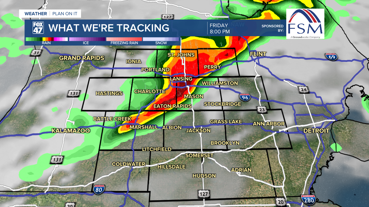
A severe line of storms with confirmed tornadoes has been moving across Michigan on Friday, according to the National Weather Service.
Update: 7:01 P.M.
Severe Thunderstorm Warning including Lansing MI, East Lansing MI and Holt MI until 8:00 PM EST pic.twitter.com/D01yGxBCpM
— NWS Grand Rapids (@NWSGrandRapids) March 6, 2026
Lindsey Whitaker shared this video of a tornado near Three Rivers. In the video, you'll see the Menards roof damaged from the storm.
_________________________________________________________________________________________________
Another Dense Fog Advisory is in effect for Hillsdale County this morning as trapped moisture at the surface continues to drop visibility across our neighborhoods with visibility less than a mile possible across all of our neighborhoods this morning. The Hillsdale advisory is set to expire at 10 AM this morning. However, lingering fog and surface moisture could last through the afternoon hours and possibly limit our chances for storms in the early afternoon hours.

We are tracking showers and storms today with multiple rounds. Some of these storms could produce severe impacts. We are able to tap into warm moist air as a warm front will advance through our neighborhoods during the PM hours Friday. Temperatures will be able to reach the mid to lower 60's both today and tomorrow. Expect our high temperatures to be observed late in the evening hours as we continue to warm. During the daytime, we will be seeing temps into the mid to upper 50's.

WATCH THE FULL FORECAST BELOW
The Storm Prediction Center has maintained the marginal risk for isolated severe storms Friday evening, but extending the area of coverage to include all of our neighborhoods. The severe threat continues into Saturday morning with a marginal risk placed across all of Hillsdale County, most of Jackson County, and southeastern Ingham County.
The first round of showers and potential storms arrive during the late morning/early afternoon hours with a focus a bit further north than our neighborhoods. We could still see this track change as showers approach. However, the intensity of these showers and potential storms depends on whether our surface moisture can erode. With fog concerns possibly continuing into the afternoon hours, the best chance for severe impacts lies in the evening round of storms.

Round two arrives from the 6 PM to 10 PM time frame and is expected to arrive as a line of storms with all severe impacts possible with decent shear and instability.
We are expecting to lose instability as we head further into the overnight hours with Saturday's line of showers and storms arriving from 6 AM to Noon. As of now, main impacts include severe hail and wind with the round Saturday morning. We can't rule out the isolated tornado threat, however. We will monitor closely through the rest of the day.

Make sure to plan for all severe impacts as we head into the PM hours Friday. Severe storms should remain few and more isolated, but these impacts could still cause a lot of damage.

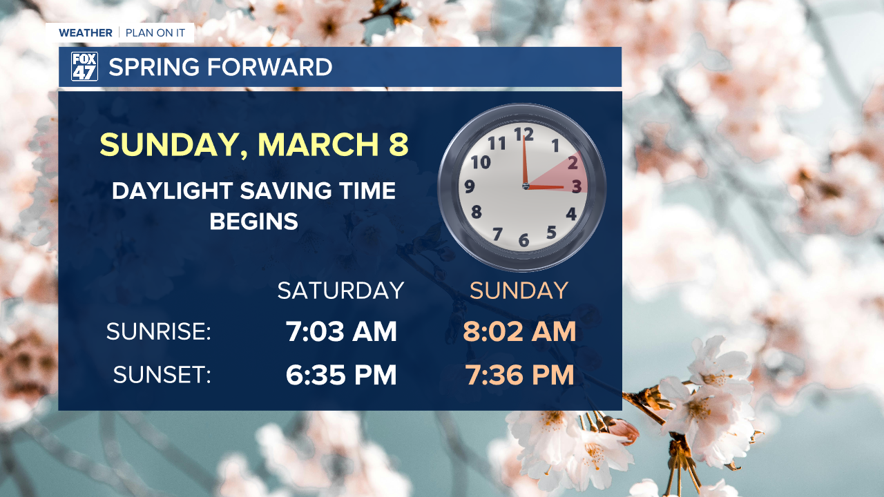
Saturday afternoon dries out with cloudy skies continuing. We will have a better chance to see some sunshine Sunday as well as Monday with mild temperatures continuing. However, strong winds are still favored Sunday which also begins Daylight Saving Time where we will lose an hour of sleep and turn those clocks ahead an hour.
Our next best chance for precipitation comes during the midweek period next week with showers and a possible thunderstorm Tuesday with gradually cooling temperatures late next week with some possible wintry mix sneaking into the forecast Wednesday. We could still see changes to this forecast and will keep watching.


Want more FOX 47 News? Here's how you download our Roku app
You can also see the latest news from across our mid-Michigan neighborhoods by liking us on Facebook or following us on X.
