
Showers and Storms Return Tonight, Then a Comfortable Stretch of Summer WeatherAfter several days of intense heat, a much more comfortable weather pattern has settled across Mid-Michigan. While a few showers and thunderstorms are still possible tonight and again Sunday afternoon, much of next week looks dry with seasonable temperatures in the 80s.
Storm Chances Continue Tonight
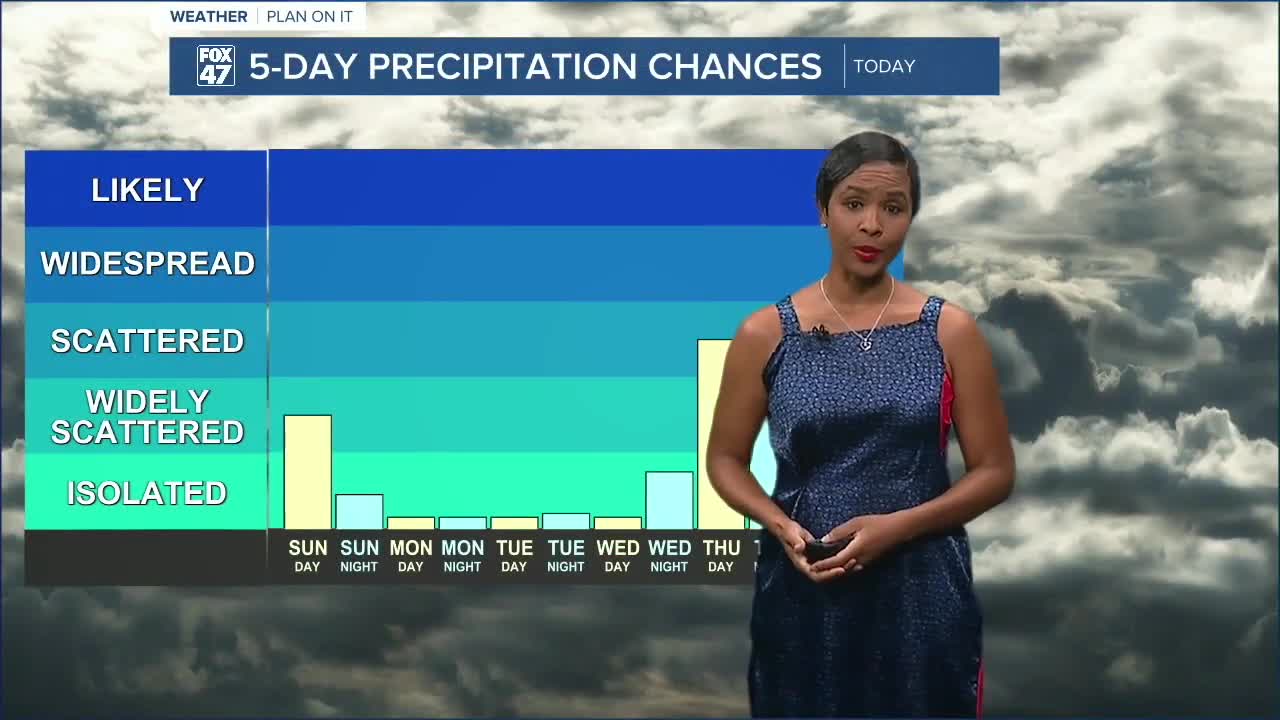
A few showers and thunderstorms may linger overnight, especially across communities south of I-96 and closer to the I-94 corridor. A weak weather disturbance moving through northern Illinois will be the trigger, but rainfall coverage is expected to remain scattered.
Some locations along I-94 may stay completely dry overnight.
Tonight's lows will fall to around 64 degrees with light winds.
Sunday: Isolated Afternoon Thunderstorms
Sunday will feature a mix of sunshine and clouds with warm, comfortable temperatures in the lower 80s.
As daytime heating develops, scattered showers and thunderstorms are expected to form mainly during the afternoon and early evening. The greatest chance for storms will be along and east of a line from Kalamazoo to St. Johns, including the Lansing and Jackson areas.
While lightning and brief downpours are possible with any storm, widespread severe weather is not expected.
Dry Weather Returns to Start the Week
High pressure takes control beginning Monday, bringing several days of quiet summer weather.
Monday through Wednesday will feature:
- Mostly sunny to partly cloudy skies
- Afternoon highs in the lower to middle 80s
- Comfortable overnight lows in the upper 50s and lower 60s
- Lower humidity compared to last week's heat wave
It will be an excellent stretch of weather for outdoor activities.
Rain Chances Return Late Week
Our next weather system approaches Wednesday night into Thursday, bringing another chance for scattered showers and thunderstorms.
Forecast models still differ on exactly when the system arrives. That timing will determine whether showers linger into Friday or move out sooner. At this point, severe weather does not appear to be a significant concern.
7-Day Forecast
- Sunday: Isolated afternoon thunderstorms. High 82°.
- Monday: Mostly sunny and pleasant. High 83°.
- Tuesday: Mostly sunny. High 86°.
- Wednesday: Mostly sunny and warm. High 89°.
- Thursday: Chance of showers and thunderstorms. High 88°.
- Friday: Partly cloudy with a slight chance of lingering showers. High 84°.
- Saturday: Mostly sunny and comfortable. High 84°.
Overall, temperatures will remain much closer to normal throughout the week, offering a welcome break from the extreme heat that impacted the region over the past several days.
Have a great weather picture or video to share? Send it our way and we may feature it on-air or online!

