


LANSING, Mich. — CURRENT CONDITIONS:
Severe weather is moving out of our neighborhoods. Severe thunderstorm warning in effect for Washtenaw County until 1:30 a.m. TORNADO WATCH IS NOW CANCELED FOR INGHAM COUNTY.
PREVIOUS UPDATES:
A new TORNADO WARNING is now in effect for Ingham County. See shelter. Radar indicated rotation. * These dangerous storms will be near Lansing, Mason, and East Lansing around 1140 PM, Williamston around 1150 PM.
A new TORNADO WARNING is in effect for Clinton County until 12:15 a.m. Seek shelter.
A TORNADO WARNING is now also in effect for Eaton, Calhoun, and Ionia counties until 11:45 p.m. This cluster of thunderstorms is capable of producing tornadoes and widespread severe wind damage. Move to safety now. The lowest floor of your home or a sturdy building is best. Avoid windows. If you are outdoors, or in a mobile home or vehicle, move to the closest substantial shelter and protect yourself from flying debris.
(In Eaton County, radar indicated rotation has been reported.
A TORNADO WARNING is now in effect until 11:30 p.m. for Barry and Allegan counties. If you are in those areas, please get to safety now.
A TORNADO WATCH has been issued until 3:00 AM for the following counties: BARRY, CALHOUN, CLINTON, EATON, INGHAM, IONIA, JACKSON.
Torrential downpours are occurring with these storms and may lead to flooding. Severe thunderstorm warnings are also in effect for neighborhoods that are not yet under a tornado warning. However, there is still a threat of 70mph wind gusts during these storms, and a tornado is possible.

Following Thursday's mostly sunny skies and highs that soared into the low and mid 80s, our atmosphere is primed with favorable conditions for strong to severe storms this evening. Severe thunderstorms are already underway across Minnesota and Wisconsin, and that activity will begin to sweep into Michigan and our neighborhoods between 9:00 PM and 1:00 AM.

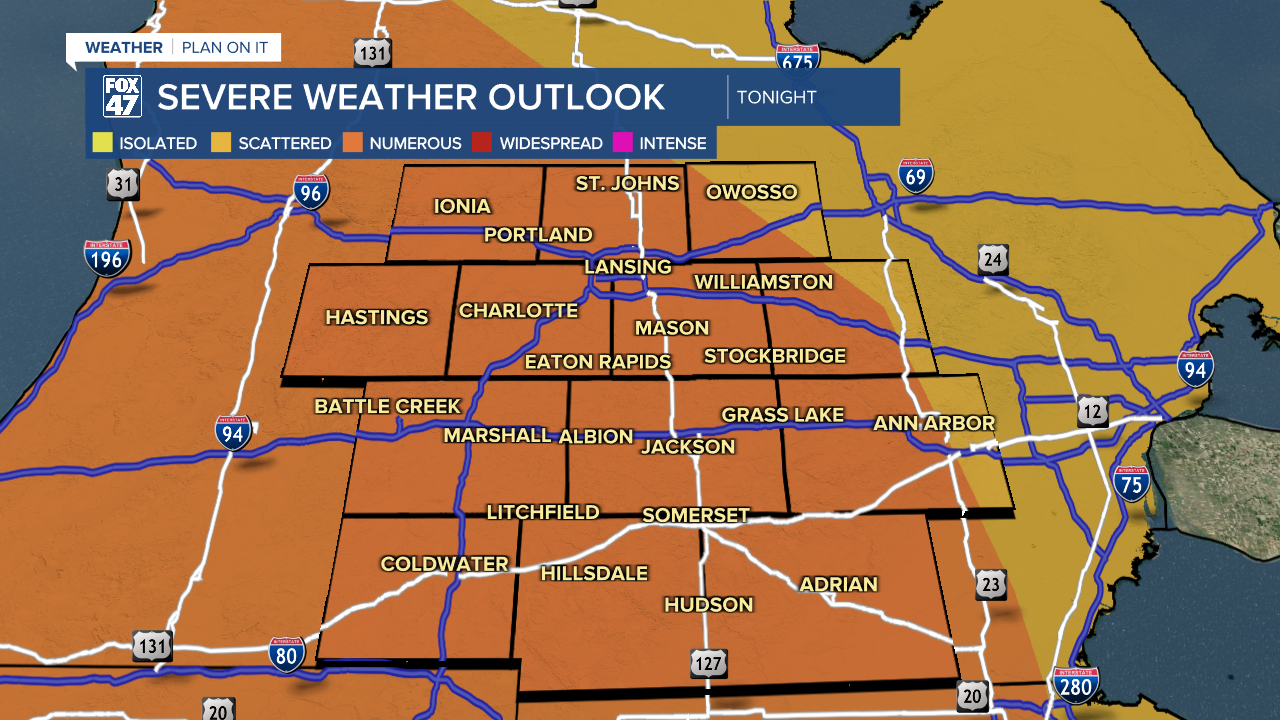
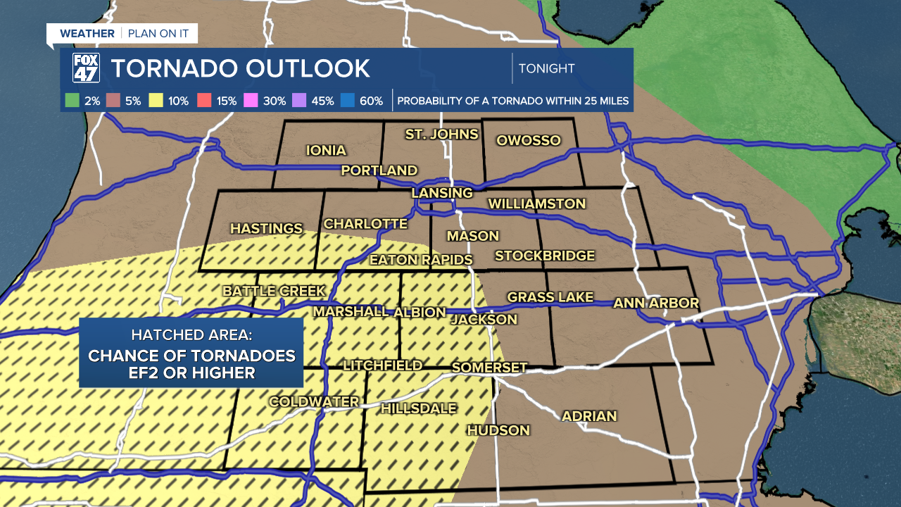
Conditions are expected to be favorable for tornadoes, damaging winds, large hail, with the added potential for some of these to be particularly destructive. Along with an elevated risk for tornadoes in general, locations south and west of Lansing face the potential of EF2 tornadoes or stronger.
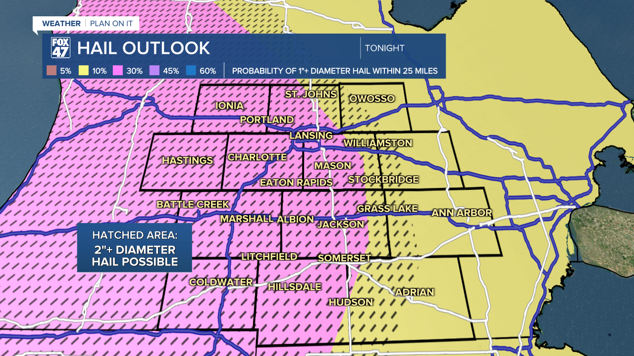
While all of our neighborhoods face the risk of damaging winds, some storms could produce hurricane-force winds in excess of 74 mph. 1"-2" diameter hail will be possible as well. Be prepared to seek shelter on the lowest level of your home if and when warnings are issued for your area.

Skies will clear behind the storms overnight, with lows eventually settling into the low 60s.
Mostly sunny skies will carry us through the majority of the day on Friday, but another round of showers and storms is expected later in the evening as a cold front finally moves through the region. These storms are expected to be much less intense than tonight's storms, but an isolated severe storm cannot be entirely ruled out. Highs will top the low 80s again on Friday before a weekend cooldown.

The cold front will usher in a big cooldown for the weekend, with highs falling back to the low 60s both Saturday and Sunday. Skies will run mostly cloudy both day, with the slight chance for a few showers on Saturday.
Want to learn more about the Weather? Visit the FOX47News Website.
Stay in touch with us anytime, anywhere.
Sign up for newsletters emailed to your inbox.
Select from these options: Breaking News, Severe Weather, School Closings, Daily Headlines and Daily Forecasts.
