

Monday offered up a welcome break from this past weekend's rainy weather. That rain did prove to be quite beneficial across our neighborhoods, with many areas picking up totals well over the 2" mark. Monday's blue skies and sunshine were made even more welcome by the fact that rainy weather will be making a comeback over the next couple of days.

Scattered showers will accompany the increasing clouds overnight, rolling in around 2:00 AM. These will be quick-hitters, moving out of the region in time for the morning commute. Still, be prepared for some leftover wet spots on the roads in the morning, with lows falling to the upper 40s around daybreak.

Leftover wet spots aside, we'll start off dry on Tuesday morning with a mix of sun and clouds on our way out the door. Despite the morning sunshine, make sure to take an umbrella with you, as an area of low pressure will bring clouds and showers back in time for the afternoon. Making things less pleasant, a fresh batch of chillier air will be rolling in with the showers, with highs hovering in the mid 50s.

Chances are low compared to this past weekend, but isolated thunderstorms will also be possible during the afternoon and evening. Severe weather is not expected, but storms that do develop could produce heavy downpours and gusty winds. Expect a breezy day regardless of storms, with westerly winds at 10-20 mph and gusts up to 30 mph at times.
GET YOUR FOX 47 FORECAST HERE
With low pressure hovering over the state, showers will continue Tuesday night and through the day on Wednesday. Expect the same breezy, raw conditions with highs Wednesday climbing to around 50 degrees at best. A few neighborhoods might not even make it out of the upper 40s, putting us around 10 degrees below normal for late-October!

The disturbance finally begins to move away on Thursday, but the chance for a few leftover showers will remain. We should manage to sneak in a few breaks of sunshine, but it will remain chilly with highs in the low 50s.
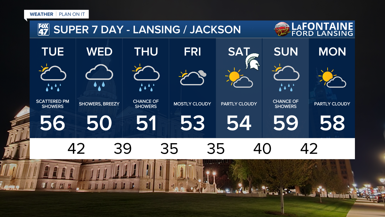
Things will fare better for Friday and Saturday, finally getting the wet weather out of the picture for a little bit. Mostly cloudy skies will continue on Friday, but winds will ease up a bit with highs still in the low 50s. Saturday stays crisp in the mid 50s, but it will be a sunnier overall. That will set us up for a chilly, but beautiful evening for the big in-state showdown in East Lansing!
Want more FOX 47 News? Here's how you download our Roku app
You can also see the latest news from across our mid-Michigan neighborhoods by liking us on Facebook or following us on X.
