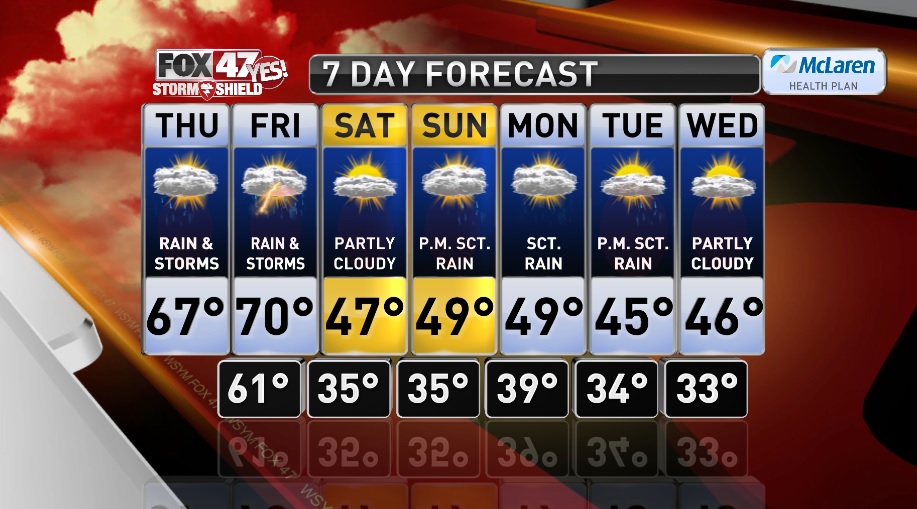

LANSING, Mich. — A warm front will bring warmer temperatures, scattered showers, and possibly a few thunderstorms to the area today. Rain and storms will last through the afternoon before we dry out and see some clearing this evening. Our daytime temperatures will top out near 60 degrees, and then temperatures will continue to rise as we go into the later evening hours. High temperatures will likely be set just before midnight in the mid 60s. Temperatures will remain warm throughout the overnight hours with partly cloudy skies and lows in the mid 60s.
Friday will be our warmest day of the week with highs climbing to near 70 degrees earlier in the day. The warm-up will be short lived, as we have a strong cold front expected to move through the area Friday afternoon and evening. The cold front will come through with another round of showers and possibly a few thunderstorms. Behind the front temperatures will fall quickly and drop into the low 50s by 5 P.M., eventually falling into the mid 30s Friday night.
Much colder air will pour into the region for the upcoming weekend. Saturday and Sunday will be about ten degrees below average with highs in the upper 40s. Saturday will be partly cloudy and a few more clouds will build in for Sunday. Rain chances return to the forecast Sunday night through Tuesday. Temperatures through nect week will remain below average with highs in the mid to upper 40s.
Want to learn more about the Weather? Visit the FOX47News Website.
Stay in touch with us anytime, anywhere.
and
Sign up for newsletters emailed to your inbox.
Select from these options: Breaking News, Severe Weather, School Closings, Daily Headlines and Daily Forecasts.
