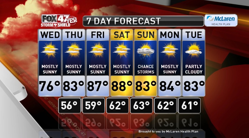

LANSING, Mich. — A copy and paste kind of forecast in store for today before we warm up the rest of the week. We will see almost exactly the same weather conditions as yesterday. Mostly sunny with highs in the mid 70s this afternoon. Humidity remains low, and there will be a nice northerly breeze, so you can open up the windows again. Skies stay mainly clear tonight with just a few thin clouds and it will be cool with lows in the mid 50s.
Warmer temperatures then begin to take over by the end of the work week. Daytime highs reach into the low 80s tomorrow with plenty of sunshine. Mostly sunny Friday with highs in the mid to upper 80s and a touch more humidity, but it won’t be oppressive.
Heading into the weekend we start dry then end with some rain. Mostly sunny and hot on Saturday with highs in the upper 80s to near 90 degrees. Scattered showers or storms will be possible as a Sunday as a weakening cold front moves through the state. Best time frame for scattered showers and thunderstorms would be Sunday afternoon. Rain ends and we should see some clearing take place Sunday evening. Temperatures look to stay warm with highs in the low 80s on Sunday.
The trend of above average temperatures then continues into early next week with highs in the low to mid 80s Monday under mostly sunny skies. A few more clouds Tuesday with highs in the low 80s, and we stay dry.
Want to learn more about the Weather? Visit the FOX47News Website.
Stay in touch with us anytime, anywhere.
Download our free app for Apple and Android
and
Sign up for newsletters emailed to your inbox.
Select from these options: Breaking News, Severe Weather, School Closings, Daily Headlines and Daily Forecasts.
