
LANSING, Mich. — Overnight:
We stay mostly dry overnight, but colder air continues settling in across our neighborhoods.
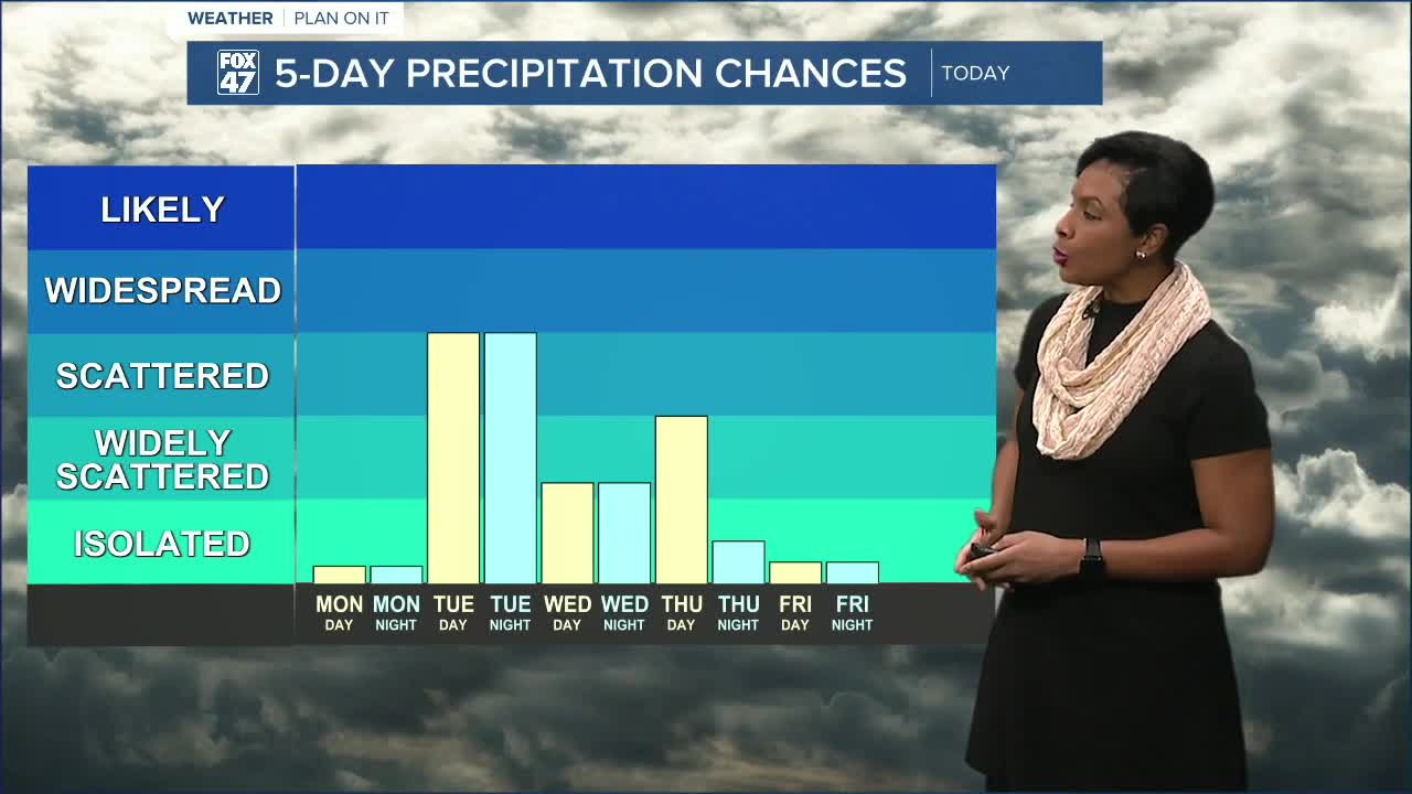
Skies remain mostly cloudy tonight with just a few isolated snow showers possible east of Perry and Williamston. Most areas stay dry. Overnight lows fall to around 20 degrees, so expect a cold start Monday morning.
Monday: Cold Start, Partly Sunny Finish
Monday begins mostly cloudy, but we’ll start seeing breaks in the cloud cover by mid-morning. By late morning and into the afternoon, partly sunny skies take over.
Despite the sunshine, it will be cold.
Morning temperatures around 8 a.m. sit near 21 degrees, but wind chills will make it feel closer to 9 degrees. By mid-afternoon, highs reach only 27 degrees, with wind chills hovering in the teens.
It’s dry, but bundle up — winter coats are still necessary.
Monday night drops to around 13 degrees under partly cloudy skies.
Tuesday: Clipper Brings Snow Showers
Clouds increase Tuesday ahead of a fast-moving clipper system.
By late afternoon and evening, snow showers become more widespread across our neighborhoods. Snow continues into the evening hours before tapering to more isolated activity by late Tuesday night.
Highs Tuesday reach 34 degrees.
These are not heavy snow events, but brief bursts of snow could create minor travel impacts.
Low Tuesday night: 26 degrees.
Wednesday: Weak System, More Flurries
Another weaker low-pressure system moves through Wednesday.
Expect mostly cloudy skies with isolated snow showers. Highs top out near 32 degrees with lows around 20 degrees.
Thursday: Another Round of Snow Showers
Yet another system arrives Thursday, bringing additional light snow showers across Mid-Michigan.
Highs reach 33 degrees.
Again, these look to be lighter snow showers rather than significant accumulation, but several systems moving through will keep conditions unsettled.
Friday and Saturday: Sunshine and 40s
We finally dry out Friday.
High pressure builds in, bringing sunshine and a rebound into the mid-40s Friday and mid-40s again Saturday.
After several colder days and light snow chances, it will feel much more comfortable to end the workweek.
Next Sunday: Temperature Whiplash
Enjoy the mild stretch while it lasts.
By next Sunday, temperatures dip back into the lower 30s, with partly sunny skies and a high near 30 degrees.
Winter isn’t quite ready to let go.
The Bottom Line
Tonight stays mostly cloudy and cold. Monday turns brighter but remains well below normal. Several light snow chances move through Tuesday, Wednesday, and Thursday before sunshine and 40s return Friday and Saturday.
Then, a quick cooldown again by Sunday.
Want more FOX 47 News? Here's how you download our Roku app
You can also see the latest news from across our mid-Michigan neighborhoods by liking us on Facebook or following us on X.
