


LANSING, Mich. — Hit-or-miss showers and thunderstorms will continue this evening thanks to earlier heating and sunshine breaking out. Storms are not expected to be severe, but could produce heavy downpours and gusty winds. Keep an eye to the sky if you plan on being outdoors this evening, and stay alert for changing conditions on the roads. Temperatures will spend much of the evening in the 70s.
Showers and storms will wrap up by midnight, followed by mostly cloudy skies overnight. Lows will dip to the low 60s as our slow-moving low pressure system finally departs.
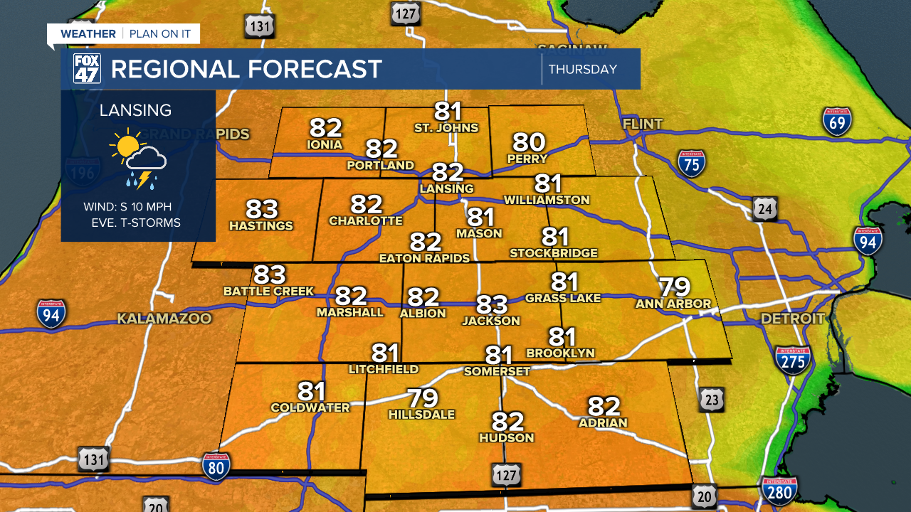
Thursday is shaping up to be increasingly sunny during the day as we settle into a gap between disturbances, but we will be bracing for a bout of strong to severe storms across our neighborhoods later in the evening. While temperatures here at the surface jump into the low 80s, a layer of warm air aloft will keep our atmosphere capped and limit thunderstorm potential during the day.

That cap will erode in the evening, ahead of a wave of strong to severe storms moving out of Wisconsin and Minnesota. The storms are expected to sweep across our area between 9:00 PM and 1:00 AM Thursday night, and will bring with them a significant risk for tornadoes, damaging winds, and large hail. Conditions could even support isolated hail over 2" in diameter, and winds over 70 mph in some storms. Take some time to secure loose objects around your home on Thursday, and be prepared to seek shelter when storms head your way. Make sure to have a way to receive warnings if you plan to be asleep before the storms arrive.


Following the storms, partly to mostly sunny skies are expected to return on Friday behind the first of two passing frontal boundaries. Highs will remain very warm in the low 80s, with southwesterly winds around 10-15 mph. A final round of non-severe storms will be possible later in the evening ahead of a second cold front, which will be followed by a much cooler air mass for the weekend.
Mostly cloudy skies will take over with the cooler air on Saturday and Sunday, with highs held to the low and mid 60s. A stray shower is possible Saturday, but the overwhelming majority of the weekend will remain dry.
Want to learn more about the Weather? Visit the FOX47News Website.
Stay in touch with us anytime, anywhere.
Sign up for newsletters emailed to your inbox.
Select from these options: Breaking News, Severe Weather, School Closings, Daily Headlines and Daily Forecasts.
