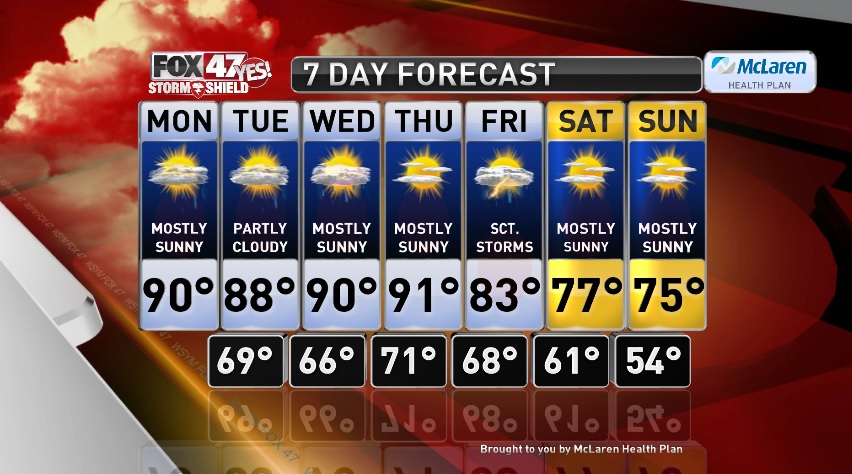

LANSING, Mich. — Hot and humid as we start the new work week. Mostly sunny for much of the day with highs near 90 degrees. There is a chance for a few isolated showers and thunderstorms this afternoon, but any activity that bubbles up will be very hit or miss so most folks stay dry. Rain will come to an end early this evening and we should remain dry overnight. Partly cloudy with low temperatures in the upper 60s tonight.
Tuesday follows a similar story. Hot and humid with highs in the upper 80s to near 90°. A few more clouds through the afternoon with a chance for pop up thunderstorms Tuesday morning and few possible Tuesday afternoon. Like today, most folks stay dry without seeing any rain and it will be partly sunny through the afternoon.
We stay hot, humid, and mostly sunny Wednesday and Thursday. Highs in the low 90s both days. There is another chance for a few afternoon storms to roll through Wednesday. Thursday will be dry through the day before showers and thunderstorms move in late Thursday night into Friday. Scattered thunderstorms then continue through Friday afternoon before drying out that evening. It will be cooler on Friday as well with highs in the mid 80s.
Cooler and less humid for this weekend. Highs will feel cooler with temperatures in the mid 70s Saturday and Sunday, but will be closer to seasonal averages for late August. Thankfully, it will also be far less humid and will feel comfortable outside. It stays dry this weekend with mostly sunny skies.
Want to learn more about the Weather? Visit the FOX47News Website.
Stay in touch with us anytime, anywhere.
Download our free app for Apple and Android
and
Sign up for newsletters emailed to your inbox.
Select from these options: Breaking News, Severe Weather, School Closings, Daily Headlines and Daily Forecasts.
