
LANSING, Mich. — Summer-like warmth is settling into Mid-Michigan, and temperatures are about to turn up another notch. While the first half of Sunday and much of Monday will be dry and pleasant, shower and thunderstorm chances return beginning Monday night and continue at times through the second half of the workweek.
Mostly Sunny and Comfortable Sunday
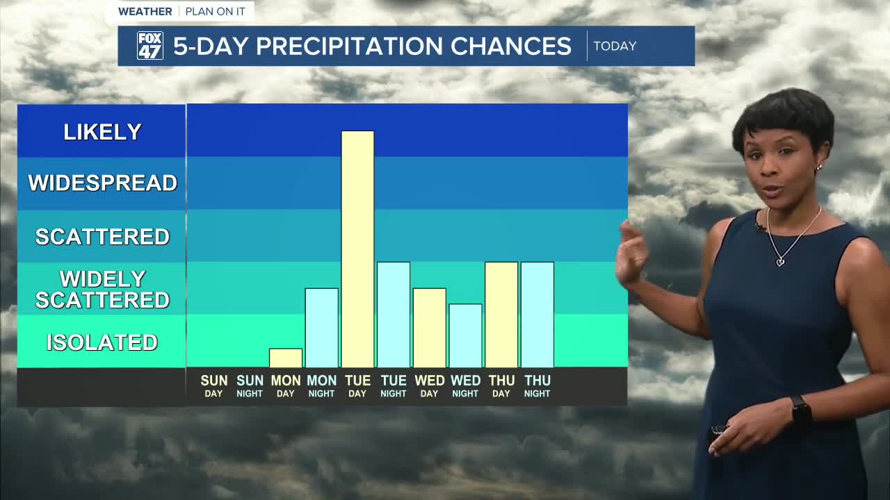
Sunday brings another beautiful day across Mid-Michigan with mostly sunny skies and highs topping out around 82 degrees.
A few fair-weather clouds may drift through during the afternoon, but overall conditions remain dry and pleasant. Overnight temperatures stay mild, falling only into the upper 50s.
Heat Builds Monday
Monday will be the beginning of a much hotter stretch of weather.
Temperatures climb to around 87 degrees with a mix of sunshine and a few clouds. Most of the day remains dry, making it a great opportunity to spend time outdoors before storm chances increase.
By Monday evening and overnight, the next weather system begins approaching the region. While the exact timing may still change, showers and thunderstorms are expected to develop sometime Monday night.
Umbrellas Needed Tuesday Through Thursday
Tuesday currently appears to be the wettest day of the upcoming week.
Showers and thunderstorms are likely at times throughout the day as a weather system moves through the Great Lakes. Additional scattered showers and thunderstorms remain possible Wednesday and Thursday.
That doesn't mean it will rain all day, every day. There will still be periods of sunshine mixed in between rounds of precipitation, but residents should be prepared for changing conditions and keep rain gear nearby.
Hot, Hot, Hot This Week
Even with the storm chances, temperatures continue to climb.
Forecast highs across Mid-Michigan include:
- Sunday: 82°
- Monday: 87°
- Tuesday: 87°
- Wednesday: 90°
- Thursday: 93°
- Friday: 90°
- Saturday: 87°
Thursday currently looks to be the hottest day of the week, with highs reaching the lower 90s and humidity making it feel even warmer.
Good News for Lawns and Gardens
After a lengthy stretch of dry weather, the upcoming rain chances should help provide much-needed moisture for lawns and gardens.
While sprinklers may still be useful Sunday and much of Monday, Mother Nature should begin helping out once showers and thunderstorms return Monday night through the middle of the week.
Looking Ahead
The week ahead will feature a little bit of everything: sunshine, thunderstorms, and some of the hottest temperatures we've seen so far this season.
Enjoy the dry weather Sunday and Monday because by Tuesday, you'll want to keep the umbrella handy. At the same time, prepare for a significant warm-up as highs surge into the upper 80s and lower 90s through the second half of the week. 🌤️⛈️🌡️
Have a great weather picture or video to share? Send it our way and we may feature it on-air or online!

