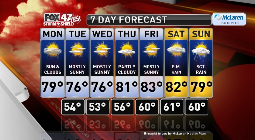

LANSING, Mich. — Cooler, almost fall-like weather in store for the start of our work week. Expect a mix of clouds and sun through the day, highs will reach the upper 70s to near 80 degrees this afternoon. There is a chance for a few spotty showers this afternoon around the peak of daytime heating, but any showers that do form will be hit or miss so not everyone will see the rain, and we should be dry by this evening. Clearing skies take over tonight and it will get chilly with low temperatures in the low to mid 50s.
Tuesday and Wednesday will be the two coolest days of the upcoming week, but also likely, the nicest. Mostly sunny skies both days with highs in the mid 70s and virtually no humidity. It will look and feel nice outside with chilly mornings, and pleasant afternoons.
A few clouds Thursday and we will warm back up to seasonal temperatures with highs in the low 80s. Sunny again Friday with highs in the low to mid 80s and a touch more humidity. Heading into the weekend we start dry then end with some rain. Partly cloudy for the first half of the day Saturday with highs in the low 80s. Scattered showers then move in Saturday evening, but it won’t be a washout. Scattered showers will continue off and on through the day Sunday with highs in the upper 70s.
Want to learn more about the Weather? Visit the FOX47News Website.
Stay in touch with us anytime, anywhere.
Download our free app for Apple and Android
and
Sign up for newsletters emailed to your inbox.
Select from these options: Breaking News, Severe Weather, School Closings, Daily Headlines and Daily Forecasts.
