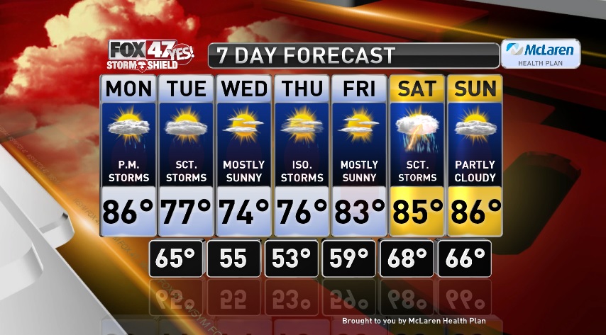

LANSING, Mich. — Warm and humid today before we cool down during the middle of the week. We are also looking at an active pattern setting up for the week ahead. Today will feature sunshine early in the day and it will be warm with highs in the mid to upper 80s. Scattered showers and thunderstorms will be possible by this evening and continue overnight. Scattered showers and storms will make it feel muggy tonight with lows in the mid 60s. Rain will carry over into the day Tuesday, with a few thunderstorms Tuesday afternoon before drying out that evening. Cooler for the middle part of the week Tuesday through Thursday with highs in the upper 70s tomorrow. Wednesday will be mostly sunny with temperatures in the mid 70s. Mostly sunny Thursday as well with a chance for a few pop up thunderstorms in the afternoon with highs in the mid 70s. We warm up again Friday with highs in the low to mid 80s and it will be sunny. Scattered thunderstorms expected Saturday with highs in the mid 80s. Partly cloudy and dry again Sunday with highs in the mid to upper 80s.
Want to learn more about the Weather? Visit the FOX47News Website.
Stay in touch with us anytime, anywhere.
Download our free app for Apple and Android
and
Sign up for newsletters emailed to your inbox.
Select from these options: Breaking News, Severe Weather, School Closings, Daily Headlines and Daily Forecasts.
