
Sunday: Cooler, Breezy, and Improving
Clouds and a few leftover showers will gradually decrease through the day as a cold front exits the region. Sunshine will become more common during the afternoon, although a northwest breeze will keep temperatures feeling a bit cooler than recent days.
Highs will reach around 70 degrees across Mid-Michigan, with wind gusts occasionally reaching 20 to 30 mph.
While it's not quite as warm as we've seen recently, Sunday still looks pleasant once the morning and afternoon showers move out.
Monday Looks Like the Best Day of the Week
High pressure settles into the Great Lakes on Monday, bringing mostly sunny skies and comfortable temperatures.
Afternoon highs will climb into the lower 70s with lighter winds and dry conditions throughout the day. If you have outdoor plans, Monday appears to be the pick of the week before the weather becomes more active again.
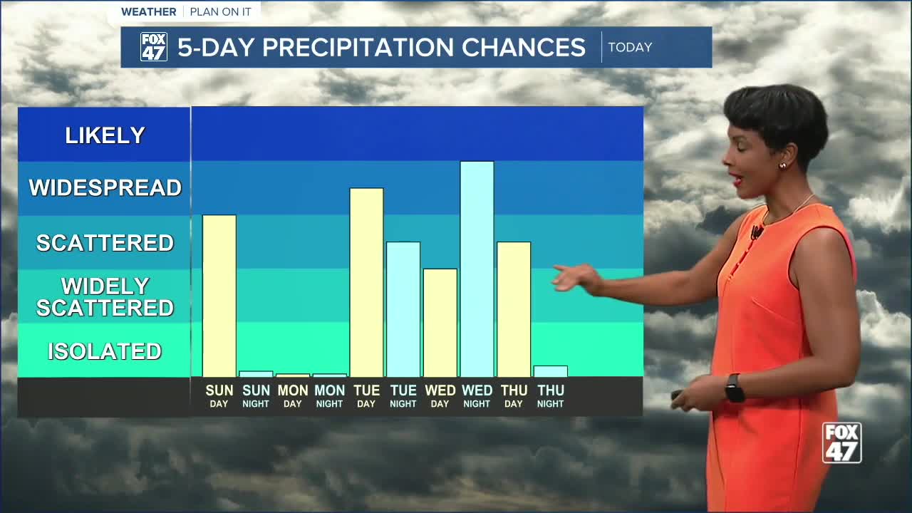
Rain and Storm Chances Return Tuesday
The quiet weather won't last forever.
Clouds increase Tuesday as the next weather system approaches the region. Showers and thunderstorms become increasingly likely during the afternoon and evening, with temperatures warming into the mid-70s.
Forecast details regarding timing and storm intensity will continue to come into focus over the next couple of days, but Tuesday is shaping up to be a wetter day across Mid-Michigan.
Widespread Rain Possible Wednesday
The most significant rain chances of the week arrive Wednesday into Wednesday night.
A stronger area of low pressure is expected to develop near the Great Lakes, bringing widespread rain and embedded thunderstorms across much of Michigan. Current forecast guidance suggests many neighborhoods could receive a beneficial soaking rainfall, with some locations potentially picking up around an inch of rain or more.
High temperatures will remain mild, reaching the upper 70s before gradually cooling later in the week.
Looking Ahead
An active weather pattern remains in place through Thursday, with multiple opportunities for showers and thunderstorms. Conditions are expected to improve by Friday as sunshine returns and temperatures remain seasonably warm.
FOX 47 7-Day Forecast
Sunday: Morning showers, then gradual clearing. High 70°, Low 50°.
Monday: Mostly sunny. High 73°, Low 54°.
Tuesday: Chance of thunderstorms. High 75°, Low 54°.
Wednesday: Showers and thunderstorms likely. High 77°, Low 59°.
Thursday: Chance of thunderstorms. High 74°, Low 54°.
Friday: Mostly sunny. High 75°, Low 56°.
Saturday: Partly sunny with a slight chance of showers. High 79°, Low 56°.
Stay with FOX 47 for updates as we continue tracking rain and thunderstorm chances expected during the middle of the week.
Have a great weather picture or video to share? Send it our way and we may feature it on-air or online!

