LANSING, Mich. — After an eventful end to the week last week, we will be seeing more tame weather conditions this week. That doesn't mean it will be filled with spring warmth and sun, however. Highs to start the week will range in the lower 60's today. We should be seeing daytime highs in the lower 70's. This is due to our northerly winds transferring cooler air into our neighborhoods.

This trend will continue through the entire week as our next arriving area of low pressure will remain south of Michigan. This means that warmth from the south won't track north enough to reach the state of Michigan.
WATCH THE FULL FORECAST BELOW
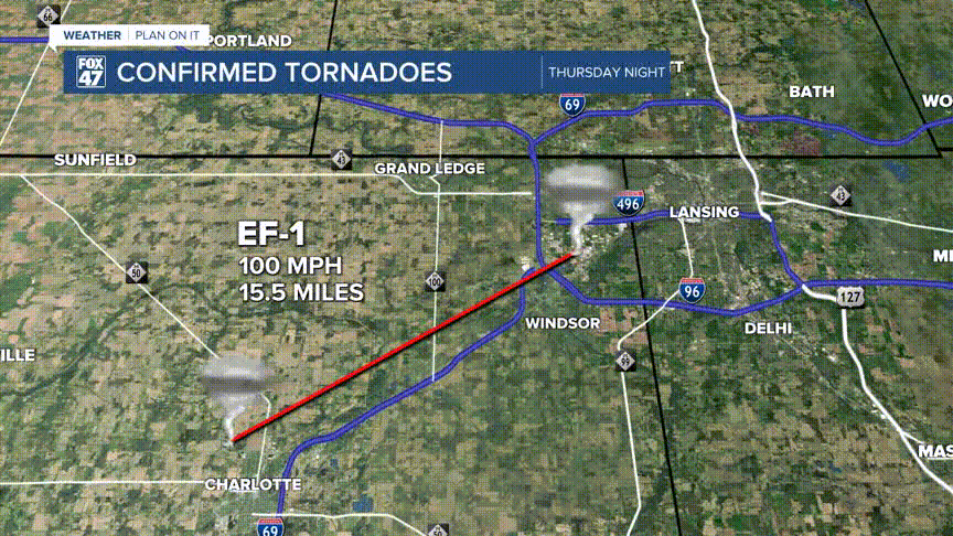
We do have rain in the forecast this week, however, severe impacts are not expected. Below you can see some of the confirmed tornadoes from the May 15-16th severe weather event. As of Monday morning, there are 9 confirmed tornadoes in southern Michigan. 4 of which are located in and around our neighborhoods.
The rain we will be seeing this week will come from an area of low pressure, currently off to the west that will continue to track east through the week. Rain is expected to begin Tuesday afternoon at around noon. These showers will continue through Wednesday as the main impact we will see is heavier precipitation rates and possibly some rumbles of thunder. However, instability is running low with a lack of sunshine and moisture.

Tuesday afternoon, we could also see winds pick up in our western neighborhoods including Charlotte, Eaton Rapids, Hillsdale, and Albion. Gusts could exceed 30 mph. Make sure to bring in any light objects from outside and bring them in for the afternoon.

Frost potential throughout the week looks low, but we will monitor our overnight temps very closely. Frost development is greater when we have clear skies in the overnight hours and our air temperatures overnight range from the upper 30's and cooler.

Want to learn more about the Weather? Visit the FOX47News Website.
Stay in touch with us anytime, anywhere.
Sign up for newsletters emailed to your inbox.
Select from these options: Breaking News, Severe Weather, School Closings, Daily Headlines and Daily Forecasts.
